
Year first lit 1986 (current) Characteristic Fl W 8s. Range 31,484 m Year first constructed 1897 | Deactivated 1986 (second) Admiralty number D2792 Focal height 35 m Spain number ES-12220 | |
 | ||
Construction concrete tower (current) Markings / pattern red and white bands, grey lantern dome (current) Tower shape cylindrical tower with double balcony and lantern (current) Height 30 metres (98 ft) (current); 7 metres (23 ft) (first); 15 metres (49 ft) (second) | ||
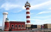
The Tostón Lighthouse (Spanish: Faro de Tostón) or El Cotillo Lighthouse is an active lighthouse on the Canary island of Fuerteventura. The lighthouse is situated on the north-western coast of the island near to the village of El Cotillo, in the municipality of La Oliva. In conjunction with the lights at Pechiguera and Punta Martiño, it marks the narrow La Bocayna strait that separates Fuerteventura from the adjacent island of Lanzarote.
History
The current lighthouse is the third in a succession of lights that have operated at the site on the promontory of Punta Tostón, which is also known as the Punta de la Ballena (whale point).
The original lighthouse was opened in 1897, and consisted of a 7m high plain masonry tower on one corner of the single storey keeper’s house. In the 1950s a new 15 metre concrete tower was constructed, which was also superseded by a taller tower in the 1980s. This distinctive 30m concrete tower, which is white with red bands, has a focal height of 35m above the sea. Its light can be seen for 14 nautical miles, and consists of a flash of white light every eight seconds.
The original keeper's house has been renovated and reused as a museum with a small café. Visitors to the museum which contains an exhibition describing the traditional fishing of the island, can also climb to the top of the 1950s concrete tower.
A short c. 1 km self-guided walking trail circles the lighthouse. Multilingual signs describe the geology, shellfish and wildlife found on the headland. Most notable is the description of the Aljibe, a water collection system, next to the road leading to the lighthouse, which was used to provide drinking water for the keepers and their families.