
OS grid reference SD768559 Sovereign state United Kingdom Postcode district BD23 Dialling code 01729 | Post town SKIPTON | |
 | ||
Shire county LancashireNorth Yorkshire Region North WestYorkshire and the Humber UK parliament constituencys Ribble Valley, Skipton and Ripon | ||
Tosside is a small village on the border of North Yorkshire and Lancashire in Northern England. It lies within the Forest of Bowland, and is between the villages of Slaidburn in Lancashire and Wigglesworth in North Yorkshire. It lies 11.5 miles north of Clitheroe and 17 miles northwest of Skipton. The village is 870 feet (270 m) above sea level and lies at 54.0001°N / 2.35436°W on the B6478.
Contents
Map of Tosside, Skipton, UK
Most of the village is in Lancashire, but a few houses in the eastern part of the village are in North Yorkshire. Historically, the entire village lay within the West Riding of Yorkshire.
The western part of Tosside is the largest settlement in the civil parish of Gisburn Forest, which had a population of 151 at the 2011 Census.
History
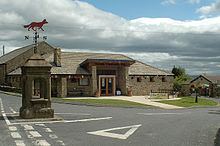
The name Tosside is believed to be derived from Old Norse/Anglo-Saxon. It can be traced back to two old Scandinavian words - 'Tod' meaning fox and 'Saetr' meaning a high summer pasture. The name gradually changed to Toddsett, then Tossett and ultimately to Tosside. This fact is recognised to this day with the symbol of the fox being present on the top of the small water fountain at the centre of the village.
The western part of Tosside was historically in the township of Gisburn Forest in the large ancient parish of Gisburn. Gisburn Forest became a separate civil parish in 1866. In 1974 it was transferred from the West Riding of Yorkshire to Lancashire.
The eastern part of Tosside was an extra parochial area known as Tosside Row. It became the civil parish of Tosside in 1858. In 1938 the civil parish was abolished and absorbed into the civil parish of Wigglesworth. In 1974 Wigglesworth was transferred from the West Riding of Yorkshire to North Yorkshire.
Village today
Tosside has a population of around 100 families scattered across a widespread area, living typically in upland farms and other remote dwellings.
The village itself includes a number of Grade II listed buildings, including St Bartholomew's Church, a chapel, and The Dog and Partridge public house.
The Village Community Hall provides a focal point for this active local community. The hall may be hired for special events and functions.
The village adjoins Gisburn Forest to the North and provides access to the forest via Bailey Lane. Gisburn Forest is the largest forest in Lancashire and is a location for mountain-biking, walking and horse-riding.
Nature reserve
To the north of Tosside village, on the lands of Heath Farm (and the former Longton's Farm), there is a nationally recognised Nature Reserve which has been developed with the direct involvement of RSPB and DEFRA/Natural England. The refuge aims to provide improved habitat for wading birds, pondlife, rare flora and fauna and aims to provide a safe haven for the benefit of wildlife in general.