
Country Spain Comarca Sierra Norte Time zone CET (UTC+1) Area 43.4 km² Local time Monday 2:16 PM | Autonomous community Community of Madrid Elevation 2,441 ft (744 m) Postal code 28180 Population 4,828 (2014) Province Community of Madrid | |
 | ||
Weather 16°C, Wind SE at 8 km/h, 34% Humidity | ||
Torrelaguna is a municipality of the Community of Madrid, Spain.
Contents
Map of 28180 Torrelaguna, Madrid, Spain
Main sights
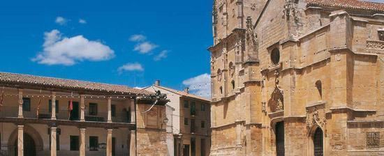
The parish church of La Magdalena (started in the 14th century, inaugurated in the 18th century) is one of the best examples of Gothic architecture in the community of Madrid.
Other sights include:
Notable people
References
Torrelaguna Wikipedia(Text) CC BY-SA