
Country Population 147,478 (2013) Area 20.553 sq mi | ||
 | ||
Colleges and Universities El Camino College, Westwood College - South Bay, Everest College-Torrance, Homestead Schools, ITT Technical Institute-Torrance | ||
Unemployment rate 5.4% (Feb 2015) | ||
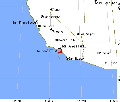
Map of Torrance, California
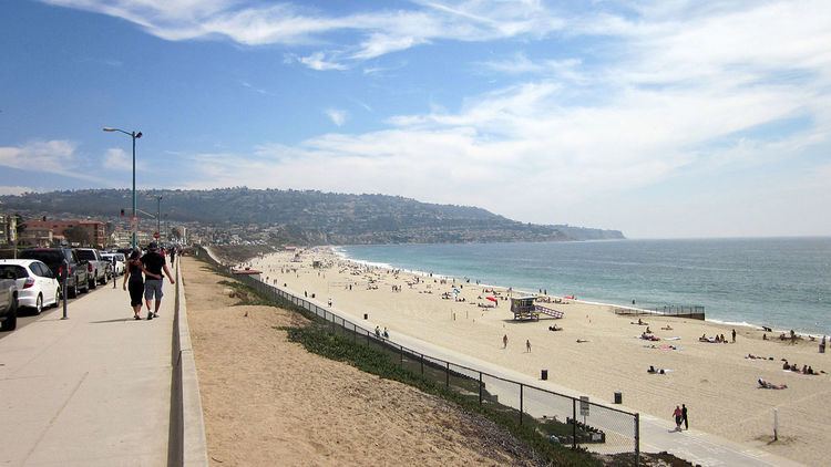
Torrance is a U.S. city in the South Bay (southwestern) region of Los Angeles County, California. Torrance has 1.5 miles (2.4 km) of beaches on the Pacific Ocean. Torrance has a moderate year-round climate with warm temperatures, sea breezes, low humidity and an average rainfall of 12.55 inches per year.
Contents
- Map of Torrance California
- Holiday inn torrance torrance california
- Making crepe cones at mitsuwa market in torrance ca
- History
- Geography
- Climate
- 2010
- 2000
- Japanese
- Koreans
- Economy
- Operations of foreign companies
- Arts and culture
- Historic landmarks
- City parks
- Local government
- Postal service
- Healthcare
- Fire
- Police
- Public library
- Transportation
- State and federal representation
- Public schools
- Private schools
- Colleges and universities
- Miscellaneous education
- Media
- Sister cities
- American fish grill order food online torrance ca clorder
- References

Since its incorporation in 1921, Torrance has grown rapidly. Its estimated 2013 population was 147,478. This residential and light high-tech industries city has 90,000 street trees and 30 city parks. Known for its low crime rates, the city consistently ranks among the safest cities in Los Angeles County. Torrance is the birthplace of the American Youth Soccer Organization (AYSO). In addition, the city of Torrance has the second-highest percentage of residents of Japanese ancestry in California (8.9%).
Holiday inn torrance torrance california
Making crepe cones at mitsuwa market in torrance ca
History
Torrance was originally part of the Tongva Native American homeland for thousands of years. In 1784 the Spanish land grant for Rancho San Pedro, in the upper Las Californias Province of New Spain and encompassing present day Torrance, was issued to Juan Jose Dominguez by King Carlos III—the Spanish Empire. It was later divided in 1846 with Governor Pío Pico granting Rancho de los Palos Verdes to José Loreto and Juan Capistrano Sepulveda, in the Alta California territory of independent Mexico.
In the early 1900s, real estate developer Jared Sidney Torrance and other investors saw the value of creating a mixed industrial-residential community south of Los Angeles. They purchased part of an old Spanish land grant and hired landscape architect Frederick Law Olmsted, Jr. to design a new planned community. The resulting town was founded in October 1912 and named after Mr. Torrance. The city of Torrance was formally incorporated in May 1921, the townsite initially being bounded by Western Avenue on the east, Del Amo Boulevard on the north, Crenshaw Boulevard on the west, and on the south by Plaza Del Amo east of where it meets Carson Street, and by Carson Street west of where it meets Plaza Del Amo. The first residential avenue created in Torrance was Gramercy and the second avenue was Andreo. Many of the houses on these avenues turned 100 years of age in 2012. Both avenues are located in the area referred to as Old Town Torrance. This section of Torrance is under review to be classified as a historical district. Some of the early civic and residential buildings were designed by the renowned and innovative Southern California architect Irving Gill, in his distinctive combining of Mission Revival and early Modernist architecture.
Historically the El Nido neighborhood was home to many European immigrants, such as originally Dutch, German, Greek, Italian and Portuguese people. These were soon joined by Mexican-American and Hispanic and Latino immigrants, employed in the growing early 20th century agriculture, petroleum, and manufacturing industries, such as the fish canneries.
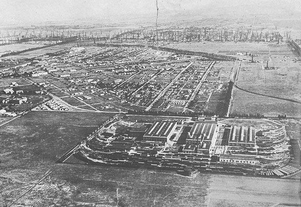
Rapid new growth in Torrance began after World War II as wartime industries transformed into post-war aerospace manufacturers and related technology industries. Large housing developments were built in the 1950s and 1960s to accommodate the new population. Torrance moved on after the closure of some aerospace development and oil refinery plants in the 1990s statewide recession.
Torrance survived the deindustrialization, regional economic slowdowns and national recessions in the 1970s to 2000s. Large-scale Asian immigration in the past couple of decades has transformed Torrance into a diverse and multicultural city.
Geography
Torrance is a coastal community in southwestern Los Angeles County sharing the climate and geographical features common to the Greater Los Angeles area. Its boundaries are: Redondo Beach Boulevard and the cities of Lawndale and Gardena to the north; Western Avenue and the Harbor Gateway neighborhood of Los Angeles to the east; the Palos Verdes Hills with the cities of Lomita, Rolling Hills Estates and Palos Verdes Estates on the south; and the Pacific Ocean and city of Redondo Beach to the west.
It is about 20 miles (32 km) southwest of Downtown Los Angeles.
Torrance Beach lies between Redondo Beach and Malaga Cove on Santa Monica Bay. The southernmost stretch of Torrance Beach, on a cove at the northern end of the Palos Verdes peninsula, is known to locals as "Rat Beach".
A rare urban wetlands, the Madrona Marsh, is a nature preserve, on land once set for oil production and saved from development, with restoration projects enhancing the vital habitat for birds, wildlife, and native plants. A Nature center provides activities, information, and classes for school children and visitors of all ages.
Climate
Torrance has a Mediterranean climate or Dry-Summer Subtropical (Köppen climate classification Csb on the coast).
The rainy season is November through March, as shown in the adjacent table.
The Los Angeles area is also subject to the phenomenon typical of a microclimate. As such, the temperatures can vary as much as 18 °F (10 °C) between inland areas and the coast, with a temperature gradient of over one degree per mile (1.6 km) from the coast inland. California has also a weather phenomenon called "June Gloom or May Gray", which sometimes brings overcast or foggy skies in the morning on the coast, followed by sunny skies by noon during late spring and early summer.
2010
The 2010 United States Census reported that Torrance had a population of 145,438. The population density was 7,076.1 people per square mile (2,732.1/km²). The racial makeup of Torrance was 74,333 (51.1%) White, 50,240 (34.5%) Asian, 3,955 (2.7%) African American, 554 (0.4%) Native American, 530 (0.4%) Pacific Islander, 7,808 (5.4%) from other races, and 8,018 (5.5%) from two or more races. Hispanic or Latino of any race were 23,440 persons (16.1%), while non-Hispanic whites formed 42.3% of the population.
The Census reported that 144,292 people (99.2% of the population) lived in households, 506 (0.3%) lived in non-institutionalized group quarters, and 640 (0.4%) were institutionalized.
There were 56,001 households, out of which 18,558 (33.1%) had children under the age of 18 living in them, 29,754 (53.1%) were opposite-sex married couples living together, 6,148 (11.0%) had a female householder with no husband present, 2,510 (4.5%) had a male householder with no wife present. There were 2,152 (3.8%) unmarried opposite-sex partnerships, and 309 (0.6%) same-sex married couples or partnerships. 14,472 households (25.8%) were made up of individuals and 5,611 (10.0%) had someone living alone who was 65 years of age or older. The average household size was 2.58. There were 38,412 families (68.6% of all households); the average family size was 3.14.
The population was spread out with 31,831 people (21.9%) under the age of 18, 10,875 people (7.5%) aged 18 to 24, 38,296 people (26.3%) aged 25 to 44, 42,710 people (29.4%) aged 45 to 64, and 21,726 people (14.9%) who were 65 years of age or older. The median age was 41.3 years. For every 100 females there were 94.7 males. For every 100 females age 18 and over, there were 91.8 males.
There were 58,377 housing units at an average density of 2,840.3 per square mile (1,096.6/km²), of which 31,621 (56.5%) were owner-occupied, and 24,380 (43.5%) were occupied by renters. The homeowner vacancy rate was 0.8%; the rental vacancy rate was 5.3%. 85,308 people (58.7% of the population) lived in owner-occupied housing units and 58,984 people (40.6%) lived in rental housing units.
During 2009–2013, Torrance had a median household income of $77,061, with 7.4% of the population living below the federal poverty line.
2000
As of the census of 2000, there were 137,946 people, 54,542 households, and 36,270 families residing in the city. The population density was 6,715.7 inhabitants per square mile (2,593.1/km²). There were 55,967 housing units at an average density of 2,724.7 per square mile (1,052.0/km²). The racial makeup of the city was 59.2% White, 28.6% Asian, 2.2% Black or African American, 0.4% Native American, 0.4% Pacific Islander, 4.6% from other races, and 4.7% from two or more races. 12.8% of the population were Hispanic or Latino of any race.
There were 54,542 households out of which 31.1% had children under the age of 18 living with them, 52.1% were married couples living together, 10.3% had a female householder with no husband present, and 33.5% were non-families. 27.5% of all households were made up of individuals and 9.1% had someone living alone who was 65 years of age or older. The average household size was 2.51 and the average family size was 3.10.
In the city, the population was spread out with 23.0% under the age of 18, 6.8% from 18 to 24, 32.4% from 25 to 44, 23.8% from 45 to 64, and 14.1% who were 65 years of age or older. The median age was 39 years. For every 100 females there were 94.7 males. For every 100 females age 18 and over, there were 91.5 males.
The median income for a household in the city in 2008 was $79,312, and the median income for a family was $98,473. Males had a median income of $50,606 versus $36,334 for females. The per capita income for the city was $39,118. About 4.7% of families and 5.4% of the population were below the poverty line, including 5.7% of those under age 18 and 7.4% of those age 65 or over.
Japanese
As of 2014 the City of Torrance has the second largest concentration of ethnic Japanese people of any U.S. city, after Honolulu. The city has headquarters of Japanese automakers and offices of other Japanese companies. Because of this many Japanese restaurants and other Japanese cultural offerings are in the city, and Willy Blackmore of L.A. Weekly wrote that Torrance was "essentially Japan's 48th prefecture". A Mitsuwa supermarket, Japanese schools, and Japanese banks serve the community.
In the pre-World War II period the South Bay region was one of the few areas that allowed non-U.S. citizens to acquire property, so a Japanese presence came. According to John Kaji, a Torrance resident quoted in Public Radio International who was the son of Toyota's first American-based accountant, the Japanese corporate presence in Torrance, beginning with Toyota, attracted many ethnic Japanese. Toyota moved its operations to its Torrance campus in 1982 because of its proximity to the Port of Long Beach and Los Angeles International Airport, and it was followed by many other Japanese companies. In 2014 Toyota announced it was moving its U.S. headquarters to Plano, Texas.
Koreans
As of 1992 about 60% of the Korean population in the South Bay region lived in Torrance and Gardena. In 1990, 5,888 ethnic Koreans lived in Torrance, a 256% increase from the 1980 figure of 1,652 ethnic Koreans.
Economy
Torrance is home to the U.S. headquarters of Japanese automaker American Honda Motor Company. Robinson Helicopters are designed and built in Torrance as are Honeywell's Garrett turbochargers, used on automobile engines worldwide. Alcoa Fastening Systems is headquartered in Torrance, producing aerospace fasteners. Pacific Sales, Pelican Products, Verengo Solar, and Rapiscan Systems are among the other companies based in Torrance.
According to the city's 2012 Major Employers in Torrance Report, the city's top 10 employers (and number of employees) are:
The Del Amo Fashion Center, at 2.5 million square feet (232,000 m²), is one of the five largest malls in the United States by gross leasable area. The current mall was created when Del Amo Center, built in 1958, merged with Del Amo Fashion Square, built in 1972. Once located on opposite sides of Carson Street, a gigantic expansion of the mall spanning Carson Street joined the two centers by 1982, making it the largest mall in the world at the time. In 2005, the east end of the original mall north of Carson Street was demolished to make way for a new open-air shopping center, opened in mid-September, 2006. This was followed in 2015 by the opening of an expanded northern Fashion Wing, with Nordstrom as the mall anchor and supplemented by luxury retailers such as Kate Spade, Hugo Boss, Uniqlo, Michael Kors, and Ben Bridge.
As a major oil-producing region, Torrance was once dotted with thousands of oil wells and oil derricks. Though the oil wells are not as common as they once were, the ExxonMobil refinery in the north end of the city is responsible for much of Southern California's gasoline supply. Torrance was also an important hub and shop site of the Pacific Electric Railway.
Torrance has a general aviation airport, originally named simply "Torrance Airport" and since renamed Zamperini Field after local track star, World War II hero and Torrance High graduate Louis Zamperini. The airport handles approximately 175,000 annual take-offs and landings (473 per day), down from the 1974 record of 428,000 operations. Airport noise abatement is a major local issue. In 2007 the Western Museum of Flight moved to Zamperini Field.
Torrance is also home to the main bakery facility for King's Hawaiian, the dominant brand of Hawaiian bread in North America. Younger Optics, Torrance's 10th-largest employer, is credited with creating the first seamless or "invisible" bifocal, a precursor to all progressive lenses.
In addition to a large corporate presence, there is a strong small business community in the city. According to a 2016 Fundera study, Torrance was ranked the 3rd best city in California for small business.
The headquarters of Mitsuwa Marketplace and Nijiya Market are located in Torrance, as well as simplehuman, a manufacturer of kitchen and bath tools.
Operations of foreign companies
All Nippon Airways operates its United States headquarters, a customer relations and services office, in Torrance.
Toyota opened its first overseas office in Hollywood in 1957, and sold 257 cars in the U.S. It moved Toyota Motor Sales USA operations to Torrance in 1982, because of easy access to port facilities and the LAX airport. In 2013 it sold 2.2 million vehicles in the U.S. In 2014 it announced it would move 3000 of its white collar employees to Plano, Texas, near Dallas, to be closer to its American factories. Numerous other Japanese firms followed Toyota to Los Angeles, because of its location and its reputation as the national trend-setter.
The Los Angeles South Bay area, as of 2014, has the largest concentration of Japanese companies in the USA.
Arts and culture
The Armed Forces Day Parade in Torrance, which was first produced in 1960, is the longest running military parade sponsored by a city. It is held annually on Armed Forces Day, and runs down Torrance Boulevard. The parade features military vehicles, school bands, and prominent community members.
The Torrance Cultural Arts Center hosts cultural events year-round. In partnership with the City of Torrance, the Torrance Cultural Arts Foundation (TOCA) provides diverse cultural, educational and entertainment experiences. Additional performances are provided by the Torrance Performing Arts Consortium, including The Aerospace Players, Torrance Art Museum, Los Cancioneros Master Chorale, South Bay Ballet, South Bay Conservatory, and The Torrance Symphony.
In the 2010 Rose Parade, City of Torrance's entry won the top Lathrop K. Leishman trophy for its Garden of Dreams float, judged as the "Most Beautiful Non-Commercial" float. In 2011, Torrance won the Tournament Volunteers' Trophy for best floral design of parade theme under 35 feet in length. In 2012, the city's entry won the Governor's Trophy for best depiction of life in California. In 2015, an entry honoring Rose Parade Grand Marshal Louis Zamperini won the Theme trophy for excellence in presenting parade theme. In 2016, the City of Torrance float won the Princess trophy for most beautiful float 35 feet and under.
Historic landmarks
These Torrance landmarks are on the National Register of Historic Places:
City parks
The Torrance City Parks Department directs and maintains the thirty Torrance City Parks. They include:
Local government
The City of Torrance is a charter city. The original city charter was voted on and ratified by the qualified electors at an election held August 20, 1946, and filed with the Secretary of State January 7, 1947. The elective officers of the city are the mayor, six members of the City Council, five members of the Board of Education, the City Clerk and the City Treasurer.
Using the council-manager form of government, the City Council, as the elected body, adopts legislation, sets policy, adjudicates issues, and establishes the budget of the city. The City Council appoints the City Manager and the City Attorney. The city has 13 appointed boards and commissions which advise the council on matters of concern to local residents, such as the city airport, arts, parks, and libraries.
The municipality is supported by a general fund budget of about $160 million. According to the city's 2007-8 Comprehensive Annual Financial Report, the city's various funds had $192.7 million in Revenues, $167.3 million in expenditures, $179.1 million in total assets, $56.1 million in total liabilities, and $140.2 million in cash in investments.
Postal service
The United States Postal Service operates the Torrance Post Office at 2510 Monterey Street, the Marcelina Post Office at 1433 Marcelina Avenue, the Walteria Post Office at 4216 Pacific Coast Highway, the North Torrance Post Office at 18080 Crenshaw Boulevard, and the Del Amo Post Office at 291 Del Amo Fashion Square. Zip codes 90277, 90501, 90503, 90504, 90505.
Healthcare
There are two major hospitals in Torrance: Torrance Memorial Medical Center and Little Company of Mary Hospital. A third hospital, Los Angeles County Department of Health Services Harbor-UCLA Medical Center, lies just outside the city limits (in unincorporated West Carson).
The Los Angeles County Department of Health Services operates the Torrance Health Center in Harbor Gateway, Los Angeles..
Fire
Police
Public library
The City of Torrance operates a main library facility (named after former mayor Katy Geissert) in the city Civic Center, plus five branches at locations throughout the city.
Transportation
Highways and freeways in the region include I-110, I-405, SR 91, SR 107, and SR 1. The city is served by Torrance Transit, LACMTA Metro bus, and LADOT services.
Zamperini Field (IATA: TOA ICAO: KTOA) is a general aviation airport. Commercial airlines service is within 15 minutes at Los Angeles International Airport and Long Beach Airport. Rail transport includes the which carries Union Pacific and BNSF along the Harbor Subdivision line.
State and federal representation
In the California State Senate, Torrance is split between the 26th Senate District, represented by Democrat Ben Allen, and the 35th Senate District, represented by Democrat Steven Bradford. In the California State Assembly, it is in the 66th Assembly District, represented by Democrat Al Muratsuchi.
In the United States House of Representatives, Torrance is split between California's 33rd congressional district, represented by Democrat Ted Lieu, and California's 43rd congressional district, represented by Democrat Maxine Waters.
Public schools
Torrance Unified School District (TUSD) was established in 1947 and unified in 1948. The district comprises the City of Torrance, bordered by the Palos Verdes Peninsula on the south, the cities of Redondo Beach and Gardena on the north, the City of Los Angeles (Harbor Gateway) on the east and the Pacific Ocean on the west. The district's jurisdiction includes approximately 21 square miles (54 km2), and it operates 17 elementary schools, eight middle schools, five high schools (one of which is a continuation school), three adult education centers, and a child development center.
The Torrance Unified School District's five high schools are:
The Torrance Unified School District's eight Middle Schools are:
The Torrance Unified School District's 17 Elementary Schools are:
Area districts have created the Southern California Regional Occupational Center (SCROC) to teach technical classes to their students and to local adults. TUSD is a participant feeder district of the California Academy of Mathematics and Science or CAMS, a mathematics and science magnet high school, administered by the Long Beach Unified School District.
Private schools
Three private high schools are also located in Torrance:
Eight private elementary/middle schools are in Torrance: Ascension Lutheran School, Riviera Hall Lutheran School, Riviera Methodist School, South Bay Junior Academy, Nativity Catholic School, First Lutheran School, St James Catholic School and St Catherine Laboure Catholic School.
In 1980 the Lycée Français de Los Angeles bought the 6.2-acre (2.5 ha) former Parkway School property, located in the Hollywood Riviera section of Torrance, from TUSD. This property became the Lycee's Torrance campus, and as of February 1990 the campus had 100 students. In November 1989 the Lycee sold the property for $2.65 million to Manhattan Holding Co. and scheduled to transfer the students to its West Los Angeles campuses. As of February 1990 neighbors of the campus site were asking the City of Torrance to not modify the zoning of this property. The Lycee stated that the campus closed due to low enrollment.
At one time Coast Christian Schools (now Valor Christian Academy) maintained a high school campus in Torrance.
Colleges and universities
Torrance is in the El Camino Community College District, although the campus of El Camino College is just outside the city limits in unincorporated El Camino Village. El Camino College was founded in 1947, and the campus covers 126 acres. As of 2011, the college enrolls over 25,000 students each semester.
Miscellaneous education
In 1980 Asahi Gakuen, a weekend Japanese-language education institution, began renting space in South Torrance High School. The school continues to use the school for its Torrance Campus (トーランス校 Tōransu-kō).
Media
The Los Angeles Times is the metropolitan area newspaper.
The Daily Breeze, a 70,000-circulation daily newspaper, is published in Torrance. It serves the South Bay cities of Los Angeles County. Its slogan is "LAX to LA Harbor". Herald Publications, media group started the Torrance Tribune, a community newspaper, which was started November 2010, it has a distribution of 15,000 newspapers to single-family homes and businesses in the City of Torrance, only.
Torrance CitiCABLE, shown on KNET 25.2, Spectrum 3, Frontier FiOS 31 is the government access channel. Programming includes news, sports, entertainment, information, public affairs, city council meetings.
Sister cities
In 1973, Torrance established a sister-city relationship with Kashiwa, Chiba, Japan, as part of the Sister Cities International program. Since then, citizens of Torrance have regularly engaged in cultural exchange with Kashiwa through the guidance of the Torrance Sister City Association, which facilitates a Japanese cultural festival, a yearly student exchange program, and contact between officials of the two cities. North High is the official sister high school of Kashiwa Municipal High.