
Country United States County Woodson FIPS code 20-71050 Elevation 290 m Zip code 66777 Local time Monday 5:50 AM | State Kansas Time zone Central (CST) (UTC-6) GNIS feature ID 0474672 Area 93 ha Population 273 (2013) Area code 620 | |
 | ||
Weather 14°C, Wind NW at 13 km/h, 96% Humidity | ||
Toronto is a city in Woodson County, Kansas, United States, along the Verdigris River. As of the 2010 census, the city population was 281.
Contents
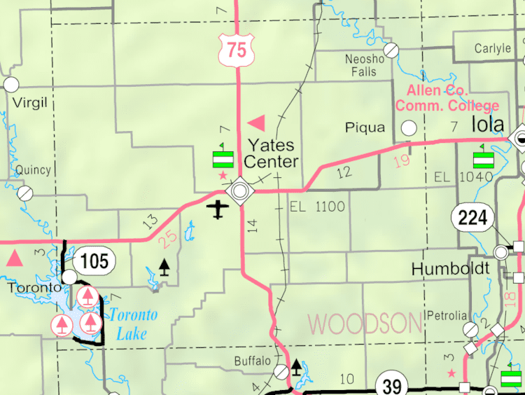
- Map of Toronto KS 66777 USA
- History
- Geography
- Climate
- 2010 census
- 2000 census
- Education
- Parks and recreation
- References
Map of Toronto, KS 66777, USA
History
Toronto was founded in 1869. It was named after the city of Toronto, Ontario. The name is derived from the Mohawk word tkaronto, meaning "place where trees stand in the water", which lies at the meeting of several rivers. In the Toronto Township Cemetery, John C. Woods is buried. He was the hangman at the Nuremberg Trials.
Geography
Toronto is located at 37°47′55″N 95°56′58″W (37.798598, -95.949555). According to the United States Census Bureau, the city has a total area of 0.36 square miles (0.93 km2), all of it land.
Climate
The climate in this area is characterized by hot, humid summers and generally mild to cool winters. According to the Köppen Climate Classification system, Toronto has a humid subtropical climate, abbreviated "Cfa" on climate maps.
2010 census
As of the census of 2010, there were 281 people, 149 households, and 72 families residing in the city. The population density was 780.6 inhabitants per square mile (301.4/km2). There were 234 housing units at an average density of 650.0 per square mile (251.0/km2). The racial makeup of the city was 96.4% White, 1.1% Native American, 0.7% from other races, and 1.8% from two or more races. Hispanic or Latino of any race were 2.5% of the population.
There were 149 households of which 18.8% had children under the age of 18 living with them, 33.6% were married couples living together, 9.4% had a female householder with no husband present, 5.4% had a male householder with no wife present, and 51.7% were non-families. 45.6% of all households were made up of individuals and 26.2% had someone living alone who was 65 years of age or older. The average household size was 1.89 and the average family size was 2.63.
The median age in the city was 53.5 years. 17.4% of residents were under the age of 18; 6.2% were between the ages of 18 and 24; 15.6% were from 25 to 44; 32.4% were from 45 to 64; and 28.5% were 65 years of age or older. The gender makeup of the city was 50.9% male and 49.1% female.
2000 census
As of the census of 2000, there were 312 people, 171 households, and 80 families residing in the city. The population density was 840.1 people per square mile (325.6/km²). There were 245 housing units at an average density of 659.7 per square mile (255.7/km²). The racial makeup of the city was 97.44% White, 0.64% Native American, and 1.92% from two or more races. Hispanic or Latino of any race were 0.64% of the population.
There were 171 households out of which 16.4% had children under the age of 18 living with them, 40.9% were married couples living together, 5.8% had a female householder with no husband present, and 53.2% were non-families. 48.5% of all households were made up of individuals and 28.7% had someone living alone who was 65 years of age or older. The average household size was 1.82 and the average family size was 2.60.
In the city, the population was spread out with 17.3% under the age of 18, 3.2% from 18 to 24, 15.7% from 25 to 44, 29.5% from 45 to 64, and 34.3% who were 65 years of age or older. The median age was 55 years. For every 100 females there were 88.0 males. For every 100 females age 18 and over, there were 85.6 males.
The median income for a household in the city was $19,643, and the median income for a family was $26,667. Males had a median income of $23,500 versus $13,929 for females. The per capita income for the city was $14,960. About 12.5% of families and 15.9% of the population were below the poverty line, including 11.5% of those under age 18 and 5.7% of those age 65 or over.
Education
Toronto is served by USD 389 Eureka.
Toronto High School was closed through school unification. The Toronto High School mascot was Trojans.