
Length 284 km Country Spain | Source elevation 1,300 m | |
 | ||
Similar Sierra de Gredos, Roman bridge of Salamanca, New Cathedral of Salam, Esla, Douro | ||
Ecoalbergue fundaci n tormes eb almenara de tormes spain amazing place
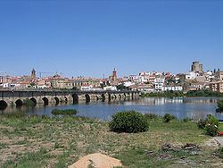
The Tormes is a Spanish river, that starts in Prado Tormejón, in the mountain range of Gredos, Navarredonda de Gredos, province of Ávila. It crosses the provinces of Avila and Salamanca, ending at the Duero river, at a place known locally as Ambasaguas, after 284 kilometres (176 mi). This river is not able to provide the water supply to the population during summer and for this reason, the dam of Santa Teresa was constructed in 1960, with a capacity of 496 million cubic metres (402,000 acre·ft) to regulate and assure the water supply in summer, as well as to moderate high flows in winter. Also it has the dam of Villagonzalo and the Almendra Dam, near to where it joins the Duero.
Contents
- Ecoalbergue fundaci n tormes eb almenara de tormes spain amazing place
- Map of Tormes Spain
- Localities by which it passes
- Tributaries
- References
Map of Tormes, Spain
Localities by which it passes
From north to south:
Tributaries
References
Tormes Wikipedia(Text) CC BY-SA