
Website www.topolovgrad.net Population 11,681 (Feb 2011) | Time zone EET (UTC+2) Area 710.9 km² | |
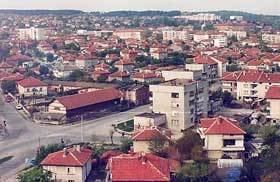 | ||
Topolovgrad Municipality (Bulgarian: Община Тополовград) is a municipality (obshtina) in Haskovo Province, Southeastern Bulgaria. It is named after its administrative centre - the town of Topolovgrad.
Contents
Map of Topolovgrad, Bulgaria
The municipality has a territory of 710.9 km² with a population of 11,681 inhabitants, according to the 2011 census. The municipality is located mostly on the right bank of the Tundzha river, with the Sakar mountain taking up a large part of its territory. Topolovgrad municipality has a short border with Turkey to the south.
Settlements
Topolovgrad Municipality includes the following 21 places (towns are shown in bold):
Demography
The following table shows the change of the population during the last four decades.
Ethnic composition
According to the 2011 census, among those who answered the optional question on ethnic identification, the ethnic composition of the municipality was the following: