Elevation 1,084 m Local time Monday 6:38 AM | Traditional region Carinthia Municipality Črna na Koroškem Area 13.43 km² Population 35 (2002) | |
 | ||
Weather 2°C, Wind NW at 5 km/h, 85% Humidity | ||
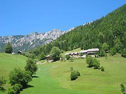
Topla ([ˈtoːpla]) is a dispersed settlement of isolated farmsteads in a valley with the same name at the foothills of Mount Peca west of Črna na Koroškem in the Carinthia region in northern Slovenia, close to the border with Austria.
Map of 2393 Topla, Slovenia
References
Topla, Črna na Koroškem Wikipedia(Text) CC BY-SA
