
Postcode(s) 4680 Postal code 4680 Population 1,164 (2011 census) | Toolooa South Trees Local time Monday 11:38 AM | |
 | ||
Weather 28°C, Wind SE at 23 km/h, 47% Humidity | ||
Toolooa is a suburb of Gladstone in the Gladstone Region, Queensland, Australia. In the 2011 census, Toolooa had a population of 1,164 people.
Contents
Map of Toolooa QLD 4680, Australia
History
The name Toolooa is believed to be derived from the Aboriginal name in the Gurang/Goeng language for nearby Barney Point and the clan of indigenous people who lived there. When the first Government Resident Maurice Charles O'Connell came to Gladstone (then known as Port Curtis), he had a house built in 1856 called Toolooa House at Barney Point. This house was sold on 12 September 1863 and burned down on 15 August 1873. The name Toolooa was later used for a railway station 7 miles (11 km) south of Gladstone, but this station no longer exists.
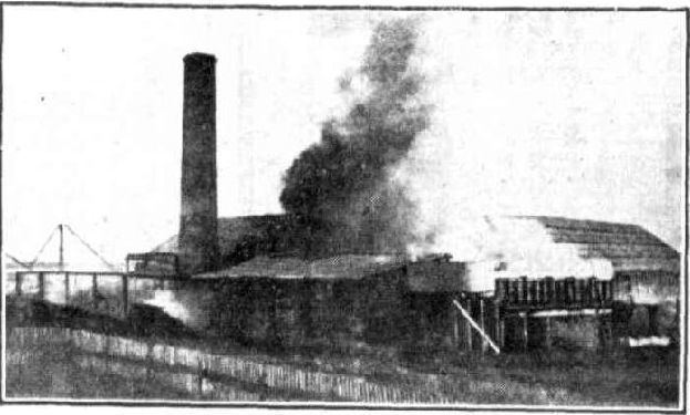
In 1900 the Bundaberg firm Messrs H. A. Skyring and Sons established a large sawmill in the area near the railway line. It employed many workers and contributed to Gladstone's growth. The mill was completely destroyed by fire on 4 April 1930.
Skyring's Siding Provisional School opened about 2 May 1905 but was soon renamed Toolooa Provisional School. It was upgraded to Toolooa State School on 1 Jan 1909 but closed on 30 April 1921.
Toolooa State High School opened on 27 January 1981 with 200 Year-8 students and 11 teachers.
Geography
Toolooa is 5 kilometres (3.1 mi) south of Gladstone Central. Toolooa borders Telina, South Gladstone, and Glen Eden and is close to The Botanical Gardens.
Glenlyon Road is the western boundary of the suburb and by the railway line to the north and east. Gladstone-Benaraby Road passes through the eastern part of the suburb.
Education
Toolooa State High School is a government co-educational secondary (7-12) school located in Philip Street.(23.874273°S 151.271142°E / -23.874273; 151.271142 (Toolooa State High School)). In 2013, the school had 839 students with 66 teachers (63 full-time equivalent).
There are no primary schools in Toolooa but these are available in nearby suburbs such as South Gladstone and Kin Kora.