
Country United States County Hennepin Population 1,523 (2013) | Time zone Central (CST) (UTC-6) Local time Sunday 5:59 PM | |
 | ||
Weather 12°C, Wind S at 14 km/h, 70% Humidity Area 256 ha (241 ha Land / 16 ha Water) | ||
Tonka Bay is a city in Hennepin County, Minnesota, United States. It is located on Lake Minnetonka between the upper and lower lakes. The population of Tonka Bay was 1,475 at the 2010 census.
Contents
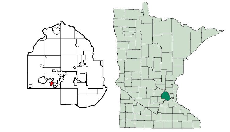
Map of Tonka Bay, MN 55331, USA
Geography
According to the United States Census Bureau, the city has a total area of 0.99 square miles (2.56 km2), of which 0.93 square miles (2.41 km2) is land and 0.06 square miles (0.16 km2) is water. Manitou Road serves as a main route.
History
Horticulturist Peter Gideon claimed 160 acres (0.65 km2) in what would become Tonka Bay. Here he propagated the "Wealthy" apple, named for his wife Wealthy Hull. Another early settler of the area was Stephen Hull. He made the first channel connecting the lower and upper lakes of Lake Minnetonka, named Hull's Narrows. It was located south of the present-day narrows, along the present day West Point Road.
2010 census
As of the census of 2010, there were 1,475 people, 586 households, and 458 families residing in the city. The population density was 1,586.0 inhabitants per square mile (612.4/km2). There were 657 housing units at an average density of 706.5 per square mile (272.8/km2). The racial makeup of the city was 97.6% White, 0.8% African American, 0.1% Native American, 0.7% Asian, 0.1% from other races, and 0.7% from two or more races. Hispanic or Latino of any race were 0.9% of the population.
There were 586 households of which 31.6% had children under the age of 18 living with them, 68.6% were married couples living together, 4.8% had a female householder with no husband present, 4.8% had a male householder with no wife present, and 21.8% were non-families. 18.9% of all households were made up of individuals and 6.1% had someone living alone who was 65 years of age or older. The average household size was 2.52 and the average family size was 2.87.
The median age in the city was 47.8 years. 23.6% of residents were under the age of 18; 5.2% were between the ages of 18 and 24; 15.2% were from 25 to 44; 41.8% were from 45 to 64; and 14.3% were 65 years of age or older. The gender makeup of the city was 51.4% male and 48.6% female.
2000 census
As of the census of 2000, there were 1,547 people, 614 households, and 456 families residing in the city. The population density was 1,622.0 people per square mile (628.7/km²). There were 651 housing units at an average density of 682.5 per square mile (264.6/km²). The racial makeup of the city was 98.64% White, 0.13% African American, 0.06% Native American, 0.39% Asian, 0.52% from other races, and 0.26% from two or more races. Hispanic or Latino of any race were 1.42% of the population.
There were 614 households out of which 34.5% had children under the age of 18 living with them, 65.5% were married couples living together, 5.0% had a female householder with no husband present, and 25.7% were non-families. 20.2% of all households were made up of individuals and 3.7% had someone living alone who was 65 years of age or older. The average household size was 2.52 and the average family size was 2.90.
In the city, the population was spread out with 24.8% under the age of 18, 4.7% from 18 to 24, 27.8% from 25 to 44, 33.9% from 45 to 64, and 8.8% who were 65 years of age or older. The median age was 41 years. For every 100 females there were 104.1 males. For every 100 females age 18 and over, there were 103.7 males.
The median income for a household in the city was $84,879, and the median income for a family was $90,783. Males had a median income of $69,375 versus $41,328 for females. The per capita income for the city was $50,825. About 1.9% of families and 2.2% of the population were below the poverty line, including 2.1% of those under age 18 and 1.5% of those age 65 or over.