
Country China Postal code 652700 | Area 1,114 km² Area code 0877 | |
 | ||
Website | ||
Tonghai County (通海县; pinyin: Tōnghǎi Xiàn) is located in Yuxi Prefecture-level City, Yunnan Province, China.
Contents
Map of Tonghai, Yuxi, Yunnan, China
Geography
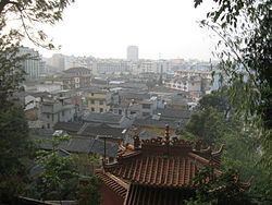
Tonghai County occupies the fertile valley of Qilu Lake, surrounded on all sides by mountains. The county seat is located on the south side of the lake, separated from the lake by a mile-wide strip of farmland.
The county' southernmost part, including the Dagao Dai and Yi Ethnic Township and Lishan Yi Ethnic Township, is separated from the rest of the county by mountains; it is outside of the Qilu Lake basin, and is drained into the Qu River instead.
In 1970, a powerful earthquake struck the area.
History
Soon after the formation of PRC, the area of today's Tonghai County was organized as two counties: Tonghai and Hexi (in the western part of today's Tonghai County). The two counties were merged into Qilu County (杞麓县) on November 22, 1956. On October 22, 1959, Qilu County was renamed Tonghai County.
The county includes a large Muslim (Hui) population. Centers of Hui culture include Dahui and Xiaohui villages in Hexi Township, as well as Nagu Town, with its Najiaying Mosque.
Xingmeng Mongol Ethnic Township, home to the Yunnan Mongols (Khatso), is the only Mongol ethnic township in Yunnan.
Transportation
Bus routes:
Railway: