
Isolation 10.74 mi (17.28 km) Prominence 709 m | Elevation 3,496 m Mountain range Sawatch Range | |
 | ||
Topo map USGS 7.5' topographic mapDoyleville, Colorado Similar Carbon Peak, Mount Zwischen, Waugh Mountain, Thirtynine Mile Mountain, South River Peak | ||
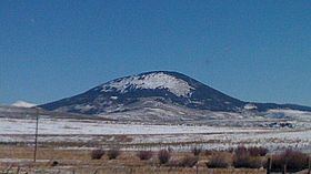
Tomichi Dome rises north of Colorado State Highway 50 west of Hot Springs Creek and south of Wanita Hot Springs Reservoir in the southeast quarter of Gunnison County, Colorado. It is situated within the Gunnison National Forest and is of a geologic formation called a laccolith. Laccolith formations are caused by igneous activity otherwise known as melting within the earth. Other laccoliths of the Gunnison Country are Mount Crested Butte, Gothic Mountain, Whetstone Mountain, Mount Axtel, Anthracite Range, Round Mountain, Carbon Peak, Beckwith Mountain, Marcellina Mountain and Mount Gunnison.
Contents
Map of Tomichi Dome, Colorado 81230, USA
Historical namesEdit
References
Tomichi Dome Wikipedia(Text) CC BY-SA