
Population 271 (2011 census) Elevation 3 m (10 ft) Region Hunter Postal code 2322 Lga Port Stephens Council | Postcode(s) 2322 Time zone AEST (UTC+10) Area 38.1 km² Local time Monday 12:26 AM | |
 | ||
Location 164 km (102 mi) N of Sydney
20 km (12 mi) NW of Newcastle
8 km (5 mi) S of Raymond Terrace Weather 18°C, Wind SE at 14 km/h, 83% Humidity | ||
Tomago is a combined industrial/semi-rural suburb of the Port Stephens local government area in the Hunter Region of New South Wales, Australia. It is located just north of the Hunter River and west of the body of water known as Fullerton Cove. Tomago means "sweet water" in the local Aboriginal language.
Contents
Map of Tomago NSW 2322, Australia
Geography
Tomago is primarily flat with sandy soil and is surrounded on three sides by water. The Hunter River flows around the western and southern borders of the suburb. To the east is Fullerton Cove. There is no direct access to the land portion of the neighbouring suburbs of Tarro, Kooragang or Fullerton Cove. Access to and from Hexham is only possible via the Hexham bridges, which are actually located in the suburb of Tarro.
Industry
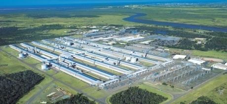
Major industrial sites in the area are the Tomago aluminium smelter, Forgacs Shipyard, Valley Longwall International and the Tomago Sandbeds water treatment works.
Hunter Region Botanic Gardens
The Hunter Region Botanic Gardens are adjacent to the eastern side of the Pacific Highway in the north of the suburb. The gardens cover an area of 140 ha (346 acres), including 30 ha (74 acres) of themed parks and 105 ha (259 acres) of natural bushland.