
Elevation 323 m (1,060 ft) Time zone CET (UTC+1) Postal code 33028 | Demonym(s) Tolmezzini Local time Sunday 12:09 PM | |
 | ||
Frazioni Cadunea, Caneva, Casanova, Cazzaso, Fusea, Illegio, Imponzo, Terzo, Lorenzaso Weather 19°C, Wind SW at 5 km/h, 43% Humidity | ||
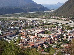
Tolmezzo (Friulian: Tumieç, archaic German: Tolmein or Schönfeld) is a town and comune in the province of Udine, part of the Friuli-Venezia Giulia region of north-eastern Italy.
Contents
Map of 33028 Tolmezzo, Province of Udine, Italy
Geography
Tolmezzo is located at the feet of the Strabut Mountain, between the Tagliamento River and the Bût stream. Nearby is the Mount Amariana, elevation 1,906 metres (6,253 ft). The commune includes aso the five frazioni of Cadunea (Friulian: Cjadugnee), Caneva (Cjanive), Casanova (Cjasegnove), Fusea (Fusee), Illegio (Dieç), Imponzo (Dimponç).
History
The existence of Tolmezzo (called Tolmetium) is first documented in the late 10th century, when it was part of the Patriarchate of Aquileia, but it has been suggested that the town stemmed from a very ancient pre-Roman settlement. In Roman times, the area was crossed by one of the main Roman roads that connect Italy to what is now Austria.
The city had a flourishing market, and was defended by a line of walls with 18 towers and by the castle of the Patriarchs. In 1420, it was annexed to the Republic of Venice, but its trades and industries did not suffer from the change, and the city maintained its privileges. In 1797, with the Treaty of Campo Formio, it was handed over to the Austrian Empire, and, after a short Napoleonic rule, it was included in the client Kingdom of Lombardy-Venetia.
Tolmezzo became part of the new unified Kingdom of Italy in 1866.