
- left Tut - elevation 1,398 m (4,587 ft) Length 185.5 km (115 mi) | - right Teirei - location Zopui Hill | |
 | ||
Natural river tlawng reiek road mizoram north east india
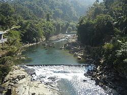
The Tlawng is a river of Mizoram, northeastern India. Tributaries include the Tut, Teirei and the Ngashih. Aizawl lies in the Tlawng valley.
Contents
Tlawng river near aizawl
Geography
Tlawng River is one of the longest river in Mizoram measuring 234 Km Length (Displacement) or 185.50Km (Distance .. in straight line) (as on the date of 23.9.2015) Between Zobawk village near Lunglei Town to Bairabi (Mizoram Border) It originates in Zopui Hill (Near Zobawk) some 8 kilometres (5 mi) east of Lunglei at an elevation of 1,395 metres (4,577 ft). After the confluence with Tut and Teirei River it eventually enters Cachar District. It is navigable by small boat up to Sairang.
References
Tlawng Wikipedia(Text) CC BY-SA