
Peak Djebel Dirrah Parent range Blidean Atlas | Elevation 1,485 m (4,872 ft) | |
 | ||
La libert ultras titteri army
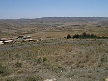
The Titteri (Arabic: جبل التيطري, Berber: Tittri) is a historical region in Algeria. It is located in the mountainous area of the southern Tell Atlas of the Atlas Mountain System.
Contents
Ultras titteri army new chant 3lamna tala3 tjrs
Geography
The Titteri was a former administrative division of the Regency of Algiers. It is located in the area of Médéa, stretching across parts of Bouïra, Djelfa and M'Sila Province as well. Its northern zone corresponds to the southern slopes of the Blidean Atlas and its southern part reaches the western Bibans. The climat of the area is semi-arid.
The highest summit of the range is 1,485 m high Djebel Dirrah (جبل ديرة). Other notable peaks of the Titteri are 1,423 m high Djebel Guern el-Adhaoura (جبل قرن العذاورة), 1,416 m high Djebel Kef Lakhdar (جبل الكاف الأخضر) and 1,400 m high Kef Afoul (جبل كاف آفول).
The main human groups inhabiting the Titteri area were mainly the Aït Ouzera, the Aït Bou Yaagoub and the Aït Slimane, who spoke the Blidean Atlas variant of the Tamazight language. Beekeeping and cattle-rearing were some of the traditional activities of the region.