
Year first constructed 1864 Automated 1925 (1st), 1984 (2nd) Height 20 m Range 33,336 m Material Cast iron | Year first lit 1865 Opened 1864 Focal height 91 m NGA number 4028 | |
 | ||
Location Tiritiri MatangiNorth IslandNew Zealand Tower shape cylindrical tower with balcony and lantern Similar Tiritiri Matangi Island, Tuhawaiki Point Lighthouse, Dog Island Lighthouse, Cape Campbell Lighthouse, Baring Head Lighthouse | ||
Tiritiri matangi lighthouse 3d laser scan flyby
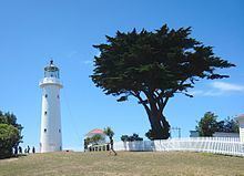
Tiritiri Matangi Lighthouse is a lighthouse on Tiritiri Matangi, an island in the Hauraki Gulf 28 km north of Auckland in the North Island of New Zealand. It is owned and operated by Maritime New Zealand. It is considered the best-preserved lighthouse complex in the country, and is the oldest lighthouse in New Zealand still in operation. It was once the most powerful lighthouse in the Southern Hemisphere.
Contents
- Tiritiri matangi lighthouse 3d laser scan flyby
- Map of Tiritiri Matangi Lighthouse Army Bay Whangaparaoa New Zealand
- History
- References
Map of Tiritiri Matangi Lighthouse, Army Bay, Whangaparaoa, New Zealand
History
Constructed in 1864 from cast iron, the light was first lit on 1 January 1865. The light was first automated in 1925 and used an acetylene burning revolving light. Keepers returned to the light in 1947 and it remained manned until 1984 when the light was fully automated. The light's last keeper, Ray Walter, remained on the island working with his wife Barbara as Department of Conservation rangers until their retirement in 2006.
The lighthouse along with the nearby visitor centre is a popular destination, although the light itself is not open to the public. The building has a Category I listing with Heritage New Zealand.