
Country Algeria Elevation 288 m (945 ft) Population 33,060 (2008) | District Timimoun Time zone CET (UTC+1) Local time Saturday 12:38 PM Number of airports 1 | |
 | ||
Weather 28°C, Wind NE at 5 km/h, 13% Humidity | ||
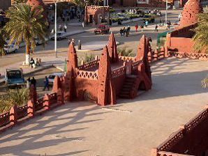
Timimoun the red oasis a town in algeria
Timimoun (Arabic: ﺗﻴﻤﻴﻤﻮن) is a town and commune, and capital of Timimoun District, in Adrar Province, south-central Algeria. According to the 2008 census it has a population of 33,060, up from 28,595 in 1998, with an annual growth rate of 1.5%.
Contents
Map of Timimoun, Algeria
Timimoun is known for the red ochre color of its buildings.
Geography
The town of Timimoun lies at an elevation of around 288 metres (945 ft) in the Gourara region of northern Adrar Province. It is located on the south-eastern side of an oasis which supports the town's population. A sebkha (salt lake) lies further to the northwest, while the plateau of Tademaït rises to the southeast.
Climate
Timimoun has a hot desert climate (Köppen climate classification BWh), with extremely hot summers and warm winters, with minimal rainfall throughout the year. The annual mean temperature almost reaches 25 °C (77 °F).