Harman Patil (Editor)

Timeline of the 2003 Pacific typhoon season

Updated on
Edit
Like
Comment
Share on FacebookTweet on TwitterShare on LinkedInShare on Reddit
Timeline of the 2003 Pacific typhoon season

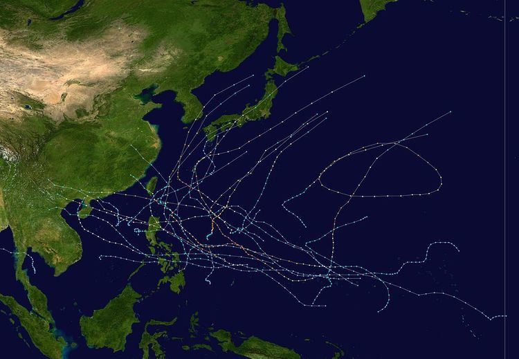
This timeline documents all of the events of the 2003 Pacific typhoon season. Most of the tropical cyclones forming between May and November. The scope of this article is limited to the Pacific Ocean, north of the equator between 100°E and the International Date Line. Tropical storms that form in the entire Western Pacific basin are assigned a name by the Japan Meteorological Agency. Tropical depressions that form in this basin are given a number with a "W" suffix by the United States' Joint Typhoon Warning Center. In addition, the Philippine Atmospheric, Geophysical and Astronomical Services Administration (PAGASA) assigns names to tropical cyclones (including tropical depressions) that enter or form in the Philippine area of responsibility. These names, however, are not in common use outside of the Philippines.

Contents

During the season, 35 systems were designated as Tropical Depressions by either, the Japan Meteorological Agency (JMA), the Philippine Atmospheric, Geophysical and Astronomical Services Administration (PAGASA), the Joint Typhoon Warning Center (JTWC), or other National Meteorological and Hydrological Services such as the China Meteorological Administration and the Hong Kong Observatory. As they run the Regional Specialized Meteorological Centre for the Western Pacific, the JMA assigns names to Tropical Depressions should they intensify into a tropical storm. PAGASA also assign local names to tropical depressions which form within their area of responsibility; however, these names are not in common use outside of PAGASA’s area of responsibility. In this season, 25 systems entered or formed in the Philippine area of responsibility, which three of them directly made landfall over the Philippines.

January

January 1
  • 0000 UTC — The 2003 Pacific typhoon season officially starts.
  • January 11
  • 0300 UTC — JTWC reports that a tropical disturbance formed near the International Dateline.
  • January 14
  • 1200 UTC — The disturbance starts to show signs of becoming a tropical cyclone.
  • January 15
  • 0600 UTC — JMA upgrades the disturbance to a tropical depression.
  • 1200 UTC — JTWC designates it as Tropical Depression 01W.
  • January 16
  • 0000 UTC — JTWC upgrades 01W to a weak tropical storm while JMA still classifies this as a tropical depression.
  • January 18
  • 1200 UTC — 01W intensifies into Tropical Storm Yanyan.
  • January 20
  • 1200 UTC — Yanyan transitions to an extratropical storm.
  • February

    No tropical cyclones developed in the month of February.

    March

    No tropical cyclones developed in the month of February.

    April

    April 8
  • 1500 UTC — Convection had strengthened through a tropical disturbance.
  • 2100 UTC — Same as Yanyan, it showed signs of intensification.
  • April 9
  • 0000 UTC — JTWC upgraded it to Tropical Depression 02W.
  • 0600 UTC — 02W maintains its strength as JMA upgraded it to a tropical depression, too.
  • April 11
  • 0000 UTC — JMA upgrades 02W to a tropical storm, giving the name Kujira.
  • 1200 UTC — Kujira enters an area of favorable environments, as the amount of rainbands and convection increased.
  • April 12
  • 0600 UTC — JMA upgrades Kujira to a severe tropical storm as an unclear eye developed.
  • 1800 UTC — JTWC upgrades Kujira to a category 1 typhoon.
  • 2100 UTC — JMA classifies the system as a typhoon.
  • April 14
  • 0000 UTC — Typhoon Kujira strengthens into a category 2 typhoon.
  • 2100 UTC — Typhoon Kujira enters an area of low vertical wind shear and warm waters and intensifies into a category 3 typhoon.
  • April 15
  • 1800 UTC — Kujira intensifies into a category 4 super typhoon, making it one of the most intense typhoons in the month of April.
  • 2100 UTC — The typhoon reaches its maximum intensity, but failed to reach category 5 strength.
  • April 16
  • 0000 UTC — PAGASA issued its first warning on Kujira, giving the local storm name Amang.
  • 1200 UTC — Kujira's large eye collapsed, due to a lack of vertical windshear.
  • April 20
  • 0300 UTC — Kujira rapidly weakens to a tropical storm and didn't made landfall over northeastern portions of the Philippines.
  • May

    May 16
  • 0000 UTC — An area of convection persisted to the southwest of Palau.
  • May 17
  • 0000 UTC — The area intensifies into a weak tropical depression according to the JMA.
  • 0300 UTC — The JTWC classifies it as Tropical Depression 03W.
  • May 18
  • 0000 UTC — JTWC has been monitoring a low-pressure area that had spawned from the area of convection.
  • May 19
  • 0000 UTC — JMA had also been monitoring the LPA, but instead they upgraded it to a weak tropical depression.
  • 0600 UTC — 03W intensifies into a tropical storm, only by the JTWC.
  • 0900 UTC — PAGASA has warned that 03W has entered their area, giving the name Batibot.
  • May 20
  • 0000 UTC — JTWC designates the new depression, 04W.
  • 0300 UTC — Batibot rapidly weakens to decreasing convection and the three agencies discontinued issuing advisories.
  • 1200 UTC — JMA upgrades it to Tropical Storm Chan-hom.
  • 1800 UTC — Chan-hom's characteristics start to intensify.
  • May 23
  • 0000 UTC — Chan-hom starts to show signs of rapid intensification.
  • 0600 UTC — The JMA upgrades Chan-hom to a typhoon.
  • 1800 UTC — Both the JMA and JTWC declares that Chan-hom reaches it maximum intensity at category 4 strength.
  • 2100 UTC — The JTWC starts to monitor an area which has a potential to become a tropical system in the next several days.
  • May 25
  • 0000 UTC — Chan-hom starts to weaken as it heads northeastward.
  • — JTWC upgrades the area to Tropical Depression 05W.
  • 0600 UTC — With the JMA and PAGASA, they upgraded it to a tropical depression too, with PAGASA naming it as Chedeng.
  • 2100 UTC — JTWC downgrades the typhoon to a tropical storm.
  • May 26
  • 0300 UTC — Both the JMA and JTWC upgrades the depression to a tropical storm, with the latter naming it as Linfa.
  • 0600 UTC — Chan-hom weakens to a tropical storm.
  • May 27
  • 0000 UTC — Chan-hom transitions to an extratropical cyclone.
  • - Linfa reaches its peak intensity as a severe tropical storm.
  • 1800 UTC — Its remnants crosses the basin.
  • May 28
  • 0600 UTC — JTWC downgrades Linfa to a tropical depression, due to land reaction.
  • - JMA downgrades Linfa to a tropical storm, however.
  • May 29
  • 0000 UTC — An area of disturbed weather occurs where Linfa formed.
  • 0600 UTC — Due to an increase of thunderstorm and convection activity near the center, JTWC reclassified it as a tropical storm.
  • 1800 UTC — Linfa reaches its second and last peak intensity, down to 980hPa.
  • May 30
  • 0000 UTC — Although, with its deep pressure, Linfa had transitioned into an extratropical storm.
  • 0300 UTC — The area intensifies to a tropical depression.
  • June

    June 1
  • 0000 UTC — Both agencies upgraded the system to Tropical Storm Nangka.
  • 0300 UTC — PAGASA also named it Dodong.
  • 2100 UTC — Nangka moves towards the Philippines and continues to intensify. The JMA classified Nangka at its peak as a severe tropical storm.
  • June 3
  • 1200 UTC — Although, due to unfavorable conditions of the storm, the JMA downgraded Nangka to a tropical depression.
  • 1500 UTC — The JTWC also downgrades Nangka to a tropical depression.
  • June 4
  • 0600 UTC — Nangka affects the Ryukyu Islands with minor effects as it becomes extratropical.
  • June 7
  • 0000 UTC — Nangka's remnants finally dissipates well east of Japan.
  • - A tropical disturbance forms over an area of moderate to high vertical wind shear northwest of Pohnpei.
  • June 9
  • 0000 UTC — JMA classifies it as a low-pressure area.
  • 0600 UTC — The disturbance steadily develops as it moves in a westward direction towards favorable environments.
  • 0900 UTC - With this, the JTWC issued a tropical cyclone formation alert (TCFA) on the system.
  • June 11
  • 0300 UTC — Shear had decreased within the area and convective activity increased near the center.
  • 0900 UTC — The JTWC assigns the designation 08W and becomes a tropical depression.
  • June 12
  • 0000 UTC — The JMA now classifies 08W to a tropical depression.
  • June 13
  • 0600 UTC — Both agencies upgrades 08W to a tropical storm, with the latter naming it as Soudelor.
  • 0900 UTC — Soudelor enters the PAR, with the PAGASA giving the name Egay.
  • June 16
  • 0300 UTC — Soudelor intensifies into a minimal typhoon by the JTWC.
  • 0900 UTC — Soudelor shows signs of possible rapid intensification in the next few days.
  • June 17
  • 0000 UTC — By the JMA, they had upgraded the storm to a typhoon.
  • 0300 UTC — Soudelor starts to affect Taiwan bringing flash floods and landslides.
  • 1200 UTC — Soudelor starts to undergo its rapid deepening phase.
  • June 18
  • 0600 UTC — Soudelor reaches its maximum intensity by both the JMA and JTWC.
  • 1800 UTC — Soudelor rapidly weakens as it becomes extratropical.
  • - Soudelor starts to affect South Korea with severe damage.
  • June 19
  • 0000 UTC — Both agencies downgrade Soudelor to a tropical depression and makes their final advisory.
  • 0600 UTC — Soudelor becomes an extratropical low.
  • July

    July 8
  • 1800 UTC — A cluster of thunderstorms formed over the Philippine Sea.
  • July 9
  • 0300 UTC — Both the JMA and PAGASA starts monitoring on it as a disorganized tropical depression, also assigning the name Falcon.
  • 0600 UTC — Although Falcon encountered some moderate vertical windshear, which caused Falcon to weaken.
  • 1200 UTC — Both agencies downgraded Falcon to a low-pressure area.
  • July 14
  • 2100 UTC — An area of convection formed over Chuuk.
  • July 15
  • 0000 UTC — The area gathers strengths with weak vertical windshear as the JMA had estimated that a tropical depression formed.
  • — In the same time the JMA had also starts tracking a tropical depression near Palau.
  • July 16
  • 1800 UTC — The tropical depression becomes 09W.
  • 2100 UTC — 09W becomes Tropical Storm Imbudo. and the JMA upgraded it to Tropical Storm Imbudo on July 17.
  • July 18
  • 0300 UTC — Imbudo has intensified into a severe tropical storm.
  • 1500 UTC — The JTWC upgrades the storm to a typhoon.
  • July 19
  • 0000 UTC — Imbudo enters a phase of rapid deepening.
  • 0300 UTC — The JMA upgrades it to a typhoon.
  • - In the same time, Imbudo entered the PAR, with PAGASA assigning the name Harurot.
  • July 20
  • 1200 UTC — The JMA had estimated that Imbudo had reached its maximum strength as a super typhoon.
  • 1800 UTC — Imbudo starts to rapidly weaken.
  • 2100 UTC — With this, Imbudo starts to undergo an eyewall replacement cycle.
  • July 22
  • 0300 UTC — Typhoon Imbudo makes landfall over central Luzon.
  • 0900 UTC — Imubdo rapidly weakens due to land reaction as it merges into the South China Sea.
  • July 24
  • 0300 UTC — As Imbudo weakens more, the typhoon made landfall west of Macau, near Guangdong, as it was considered the most strongest to hit the province since 1996.
  • July 25
  • 2100 UTC — Imbudo rapidly dissipated over the border of China and Vietnam.
  • July 31
  • 0600 UTC — The PAGASA upgrades a weak low-pressure area to Tropical Depression Juaning.
  • 1200 UTC — The JMA recognizes Juaning as a tropical depression.
  • August

    August 2
  • 0600 UTC — Juaning intensifies into Tropical Storm Morakot.
  • 1800 UTC — The JMA had reported that Morakot attained its peak strength with winds of 85 km/h (50 mph), however according to JTWC, Morakot is still intensifying at this stage.
  • 1800 UTC — Tropical Depression 11W develops northeast of Yap, as it becomes more organized and a pronounced outfow and a broad circulation.
  • August 3
  • 0600 UTC — Due to a formation of a ragged eye, the JTWC upgraded Morakot to its peak as a weak Category 1 typhoon.
  • 1500 UTC — 11W intensifies into Tropical Storm Etau.
  • August 4
  • 0000 UTC — PAGASA starts to issue bulletins on Etau, naming it Kabayan.
  • 0300 UTC — Morakot starts to weaken as it makes landfal over Taiwan Strait.
  • 1000 UTC — Due to a northwesterly track, Morakot made its second landfall over Taiwan.
  • 1200 UTC — The JMA declares that Morakot had weaken to tropical depression strength or lesser.
  • August 5
  • 0000 UTC — Morakot fully dissipates.
  • 0000 UTC — Etau fully becomes a typhoon, as an eye develops.
  • August 7
  • 0030 UTC — As recorded, Etau made its closest approach over Okinawa, which its eye was directly over the island.
  • 1500 UTC — According to JMA, Etau reaches peak intensity with 155 km/h (105 mph) winds.
  • 1800 UTC — According to JTWC, Etau reaches peak intensity as a Category 3 typhoon.
  • August 8
  • 0300 UTC — Etau rapidly weakens due to cooler air from the north and as it becomes larger southeast of Japan.
  • 1300 UTC — Etau makes landfall over Muroto, in the island of Shikoku.
  • 2100 UTC — The JMA downgrades Etau to a severe tropical storm, as it made its second landfall over Nishinomiya
  • August 9
  • 1630 UTC — Etau makes its third and final landfall over Erimo, Hokkaido, according to JMA's data.
  • 2100 UTC — Etau becomes extratropical.
  • August 13
  • 1800 UTC — The JMA starts to monitor a weak tropical depression well west of Chuuk State.
  • August 18
  • 0000 UTC — Due to an identifiable low-level circulation center, both agencies discontinued monitoring the system.
  • August 19
  • 0900 UTC — Favorable environments caused the system to redevelop once again to a tropical depression, which the JTWC designated it as 12W.
  • 1800 UTC — The JMA followed to upgrade it to a tropical depression as well.
  • August 20
  • 0600 UTC — The JTWC upgrades 12W to a tropical storm.
  • 1200 UTC — The JMA upgrades 12W to Tropical Storm Krovanh.
  • August 21
  • 0300 UTC — The JTWC classifies Krovanh a Category 1 typhoon.
  • 0600 UTC — Krovanh intensifies into a severe tropical storm.
  • August 22
  • 0000 UTC — Krovanh reaches peak intensity as a typhoon.
  • 0300 UTC — Same with JTWC, they upgraded Krovanh as a Category 2 typhoon as peak strength.
  • References

    Timeline of the 2003 Pacific typhoon season Wikipedia