
Elevation 2,460 m | First ascent Land surveyors in 1853 | |
 | ||
Easiest route From south via Schwarze Scharte Similar Tschaggunser Mittagspitze, Wiss Platte, Schijenflue, Golmer Joch, Sulzfluh | ||
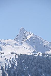
Tilisuna-Schwarzhorn (also called Schwarzhara) is a 2,460 m (AA) in the Sulzfluh sub-range of the Rätikon mountain range in the Austrian state Vorarlberg. It has a long ridge from north to south and wide scarps east and west. Besides the main summit, there is a second summit called Kleines Schwarzhorn. Both summits are separated by the col Fürkele. The alpine club hut Tilisunahütte (2208 m) is located near the Tilisuna-Schwarzhorn.
Map of Tilisuna-Schwarzhorn, 6774, Austria
First ascenionists were land surveyors in 1853. Nowadays there are two common routes to the summit:
References
Tilisuna-Schwarzhorn Wikipedia(Text) CC BY-SA