
Country United States Status Operational Length 4,300 ft (1,311 m) Opened 1956 Construction began 1952 | Opening date 1956 Height 64 m Catchment area 11,331 km² | |
 | ||
Type of dam Embankment, zoned earth-fill Owner United States Bureau of Reclamation Similar Canyon Ferry Dam, Yellowtail Dam, Clark Canyon Dam, Shadehill Dam, Jamestown Dam | ||
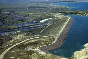
Tiber Dam, located in southern Liberty County in northern Montana, USA, is a dam on the Marias River which forms Lake Elwell, also known as Tiber Reservoir. Construction on the dam began in 1952 and it was complete in 1956. Between 1967 and 1969, a dyke was added to the southern rim of the reservoir near the dam due to difficulties with the spillway settling. From 1976 to 1989, the spillway was rehabilitated. The dam is also considered one of the biggest earth-fill dams in the world, along with Fort Peck Dam.
Map of Tiber Dam, Chester, MT 59522, USA
The dam is an earth-fill type with a length of 4,300 ft (1,311 m) and height of 211 ft (64 m). The dyke is 17,000 ft (5,182 m) long and 60 ft (18 m) tall. The dam's main spillway is controlled by three gates and has a maximum discharge of 68,467 cu ft/s (1,939 m3/s). The dam's auxiliary spillway can release up to 5,845 cu ft/s (166 m3/s) and the outlet works 1,605 cu ft/s (45 m3/s).