
Population 160 (2001 Census) Region North West Sovereign state United Kingdom Local time Friday 1:49 PM Dialling code 0151 | OS grid reference SJ246839 Country England Post town WIRRAL Metropolitan county Merseyside | |
 | ||
Weather 15°C, Wind SW at 26 km/h, 54% Humidity ISO 3166 code Metropolitan Borough of Wirral | ||
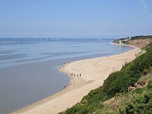
Thurstaston is a village on the Wirral Peninsula, England. It is part of the West Kirby & Thurstaston Ward of the Metropolitan Borough of Wirral. The village lies on the A540 road between Heswall and Caldy, although it extends some distance down Station Road to the bank of the Dee estuary where there is a large caravan park.
Contents
Map of Thurstaston, UK
At the time of the 2001 Census, the village itself had only 160 inhabitants, although the national census included Caldy and parts of Irby, bringing the total population to 15,548.
History
Thurstaston means "village of a man called Thorsteinn/Þorsteinn", from the Old Norse personal name Thorsteinn/Þorsteinn and Old English tún "farm, village". A record of the name as Torstestiune in 1048 proves this origin. The village was mentioned in the Domesday Book as Turstanetone. Historically and popularly, the name was wrongly thought to refer to "Thor's Stone", a sandstone outcrop on Thurstaston Common.
A Viking settlement called Straumby once existed in Tinker's Dale, near the modern-day Thurstaston Visitor Centre.
Thurstaston, including the hamlet of Dawpool, was a parish within the Wirral Hundred, in the county of Cheshire. The population was 112 in 1801, 98 in 1851, 141 in 1901 and 151 in 1951.
The village is centred on the church of St Bartholomew, and Thurstaston Hall, of which parts date from 1350, although most of the current building dates from between 1680 and 1835. A ghostly "white lady" is said to haunt the Hall.
The earliest mention of a Church occurs around 1125 but other evidence suggests that one may have existed in Saxon times. The Norman church endured for many hundreds of years but was eventually taken down in 1820 and a second edifice, a plain stone building, was completed in 1824. In 1871, the executors of Joseph Hegan of Dawpool set apart £4,500 for a new church to be erected in his memory. This was designed in late-13th-century mid-gothic style by John Loughborough Pearson, also the architect of Truro Cathedral, and was built entirely of local sandstone. It was consecrated in 1886. Although nothing remains of the earlier Norman church, the tower of the second one still stands in the churchyard and the sandstone of the building was used to construct a wall enclosing the new churchyard.
In 1882 the Liverpool shipowner Thomas Ismay, founder of White Star Line, built his mansion 'Dawpool' at Thurstaston; Ismay is said to have used his influence to ensure that the West Kirby–Hooton railway be routed a mile away along the Dee Estuary, rather than closer to the village. He was also successful in moving the main Heswall to West Kirby road, which came too close to the doorstep of his mansion, via a cutting through Thurstaston Hill. Ismay is buried in the nearby St Bartholomew's churchyard. The solidly built 'Dawpool', designed by Richard Norman Shaw, was demolished by explosives in 1927. Still standing in the village is the original building of Dawpool Primary School, now a private house.
Civic history
Between 1894 and 1933, Thurstaston was part of Wirral Rural District, then subsequently Wirral Urban District. On 1 April 1974, local government reorganisation in England and Wales resulted in most of Wirral, including Thurstaston, transfer from the county of Cheshire to Merseyside.
Geography
Thurstaston is notable for the large areas of parkland and heathland. Thurstaston Common is a Site of Special Scientific Interest (SSSI) and a local nature reserve. Nearby is Thurstaston Hill, a 298-foot (91 m) Triassic sandstone ridge and one of the highest points on the Wirral. On the eastern side of the hill is Thorstone Rock, a large sandstone mound which was reputed, in early times, to have been thrown by the Norse god Thor. The offices and a visitor centre of Wirral Country Park are near the site of Thurstaston railway station. The former trackbed of part of the Birkenhead Railway has been converted into a public footpath – the 'Wirral Way'. The visitor centre contains displays relevant to the local ecology.
Train
Thurstaston railway station, on the Chester and Birkenhead Railway branch line from Hooton to West Kirby, opened in 1886 and closed to passengers in 1954. The route is now a public footpath.