
Population 1,207 (2011) Civil parish Thurnham Local time Friday 1:35 PM | OS grid reference TQ805579 Sovereign state United Kingdom Dialling code 01622 | |
 | ||
Weather 14°C, Wind SW at 24 km/h, 68% Humidity | ||
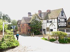
Thurnham is a village and civil parish which lies at the foot of the North Downs 3 miles (4.8 km) north east of Maidstone in the Borough of Maidstone and ceremonial county of Kent in England. It had a population of 1,085 in 2001 including Weavering, which increased to 1,205 following the 2011 Census.
Map of Thurnham, Maidstone, UK
There have been several archaeological finds in the area: an Anglo-Saxon burial ground was discovered within the grounds of Thornham Friars in 1913, a 7th-century gold cross was found in 1967 and the remains of a Roman house were excavated in 1933. The remains of Thurnham Castle are just north of the village. Two miles further north are the fragmentary remains of Binbury Castle, a medieval fortified manor house beside a medieval motte.
St Mary's church, a Norman building and Milgate House are Grade I listed buildings.
The railway station at Bearsted, opened on 1 July 1884, was originally named Bearsted and Thurnham. Residents of the village recently joined forces with the neighbouring village of Bearsted, in voicing their objections to the proposed Kent International Gateway development.