
Population 212 (2011) Civil parish Thurne Area 2.69 km² | OS grid reference TG402158 Sovereign state United Kingdom Local time Friday 1:35 PM | |
 | ||
Weather 17°C, Wind SW at 29 km/h, 61% Humidity | ||
Thurne is a small village and civil parish in the English county of Norfolk. It is located on the River Thurne in The Broads, some 18 km (11 mi) west of the town of Great Yarmouth and 20 km (12 mi) east of the city of Norwich.
Map of Thurne, UK
The civil parish has an area of 2.69 km2 (1.04 sq mi) and in the 2001 census had a population of 116 in 54 households, and at the 2011 Census including Ashby with Oby in 94 households had a population of 212.. For the purposes of local government, the parish falls within the district of Great Yarmouth.
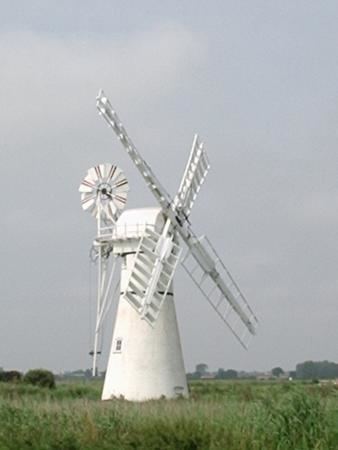
The village lies at the end of Thurne Dyke, a popular mooring, not least because of Thurne windpump, which became known locally as Morse's Mill, after the late Bob Morse, who purchased it to prevent it from being sold for scrap. Painted white it is a popular object for photography. There is a second windpump across the river, the St Benet's Level windpump.
Thurne is also home to the well-respected sailing club Theta, which has been accommodated here for over half a century and is now part of the village's character. Free moorings are available for three boats at Thurne mouth. From there it is a short walk to the village, with a large pub, the Lion Inn, and a small shop.
The Weavers' Way, a long-distance footpath, runs through the village.