
Total islands 13 Area 4.86 km² | Population None | |
 | ||
Similar Cape Maria van Diemen, Parengarenga Harbour, Ninety Mile Beach - New Zeal, Cape Reinga Lighthouse, Whakaari / White Island | ||
Deep sea fishes of the three kings islands new zealand
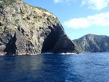
The Three Kings Islands, called Manawatawhi by Māori, are a group of 13 uninhabited islands about 55 kilometres (34 mi) northwest of Cape Reinga,of New Zealand, where the South Pacific Ocean and Tasman Sea converge. They measure about 4.86 km² in area. The islands are situated on a submarine plateau, the Three Kings Bank, and are separated from the New Zealand mainland by an 8 km wide, 200 to 300 m deep submarine trough. Therefore, despite relative proximity to the mainland, the islands are listed with the New Zealand Outlying Islands. The islands are an immediate part of New Zealand, but not part of any region or district, but instead Area Outside Territorial Authority, like all the other outlying islands except the Solander Islands.
Contents
- Deep sea fishes of the three kings islands new zealand
- Map of Three Kings Islands New Zealand
- Three kings islands
- History
- Geography
- King Group
- Southwest Group
- Flora and fauna
- Nature Reserve
- References
Map of Three Kings Islands, New Zealand
Three kings islands
History
They were named Drie Koningen Eyland on 6 January 1643 by Dutch explorer Abel Janszoon Tasman who three weeks earlier had become the first European known to have seen New Zealand.
Tasman anchored at the islands when searching for water. As it was the Twelfth Night feast of the Epiphany, the day the biblical three kings known as the wise men visited Christ the child, he named the islands accordingly. Tasman also named another prominent cape Cape Maria van Diemen, after the wife of Anthony van Diemen, Governor-General of the Dutch East Indies (now Indonesia). These are the only two geographic features in New Zealand to retain the names given to them by Abel Tasman. Tasman found the islands to be inhabited by Māori, but since 1840 they have been uninhabited. The Māori population probably never exceeded 100.
In 1945, G. T. S. Baylis made an amazing discovery on Three Kings when he found the last remaining specimen anywhere of a tree which is now called Pennantia baylisiana, a Kaikomako. It was recognised internationally as the world’s rarest and thus most endangered tree. Extremely careful propagation in New Zealand has resulted in the species being reliably established, but it continues to be carefully monitored. The islands were made a wildlife sanctuary in 1995. Other plants endemic to the islands include Tecomanthe speciosa and Elingamita johnsonii.
Geography
The Three Kings group falls into two subgroups with four main inhospitable islands and a number of smaller rocks on a submarine plateau called King Bank which rises out of extremely deep water. The surrounding sea has very clear visibility and contains teeming fish life, attracting hundreds of divers. Another attraction is the wreck of the Elingamite which foundered there on 9 November 1902.
King Group
Southwest Group
Flora and fauna
fauna
Nature Reserve
Three Kings Island is a nature reserve administered by the Department of Conservation