
Population 5,301 (2006) | ||
 | ||
Easts One Tree Hill, Royal Oak, New Zealand | ||
Three Kings is a suburb of Auckland, New Zealand that is built around the Te Tātua-a-Riukiuta volcano. It is home to an ethnically diverse population of about 5,000 people.
Map of Three Kings, Auckland, New Zealand
Three Kings is located six kilometres south of the city centre, between the suburbs of Royal Oak and Mt Roskill.
Three Kings features a small shopping mall and supermarket complex called Three Kings Plaza. It also has a commercial area, and an accident and medical clinic. The Mount Roskill library is situated above the Fickling Convention Centre which hosts a wide range of community events.
The office of Phil Goff, former Labour Party leader and MP for the Mt Roskill electorate, is in Three Kings. Goff attended Three Kings Primary School. The local state secondary school is Mount Roskill Grammar School. Catholic students attend Marcellin College (coed), St Peter's College (boys) or Marist College (girls). The local state primary schools are Mt Roskill Primary and Intermediate, Three Kings Primary, May Road Primary and Dominion Road Primary.
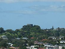
Te Tātua-a-Riukiuta, also known as Three Kings, had three prominent peaks and a number of smaller peaks until most of them were quarried away, leaving a sole remaining large peak (often called Big King). It was probably the most complex volcano in the Auckland volcanic field.