
 | ||
Highest point Mount Wellington, New Zealand Mountains Mount Wellington - New Zeal, Maungarei, Mount Richmond, Maungawhau, Te Tatua‑a‑Riukiuta | ||
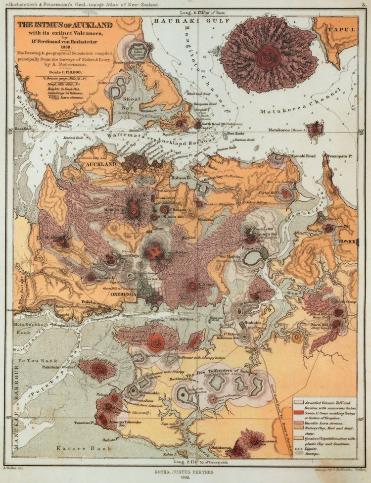
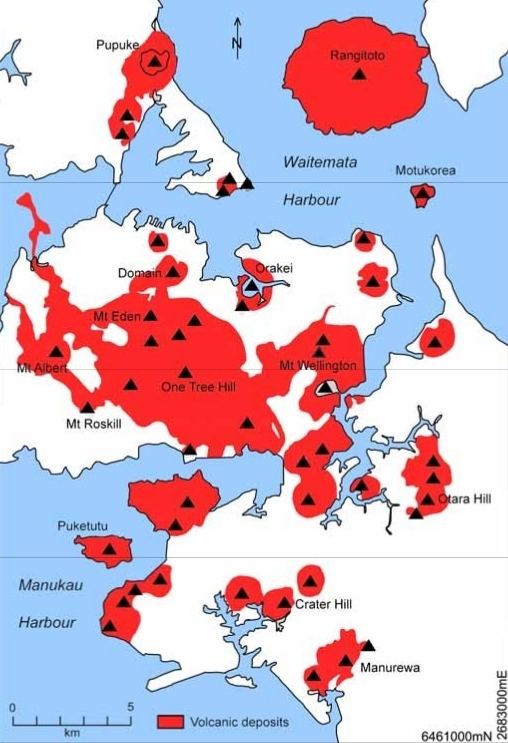
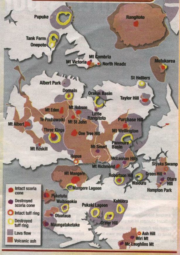
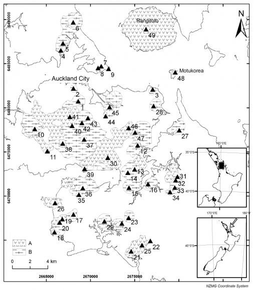
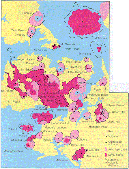
The Auckland volcanic field is an area of monogenetic volcanoes covered by much of the metropolitan area of Auckland, New Zealand's largest city, located in the North Island. The field's 53 volcanoes (or thereabouts) have produced a diverse array of maars (explosion craters), tuff rings, scoria cones, and lava flows. Each volcano has erupted for just one period, lasting for weeks to several years, except for Rangitoto Island, which erupted repeatedly. The field is fuelled entirely by basaltic magma, unlike the explosive subduction-driven volcanism in the central North Island, such as at Mount Ruapehu and Lake Taupo. The field is currently dormant, but has the potential to become active again in the future.
Contents
Features
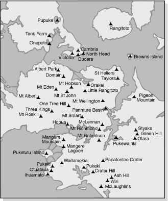
The field ranges from Lake Pupuke and Rangitoto Island in the north to Matukutururu (Wiri Mountain) in the south, and from Mount Albert in the west to Pigeon Mountain in the east.
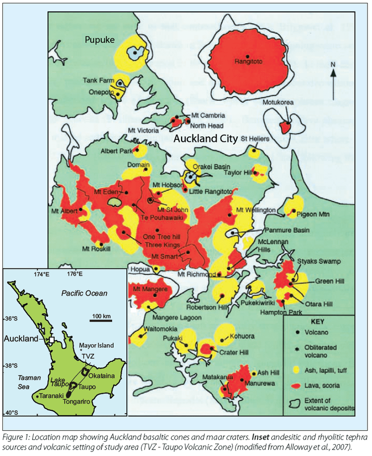
The first vent erupted at Onepoto Volcano 248,000 ± 28,000 years ago. The most recent eruption (about 600 years ago and within historical memory of the local Māori iwi) was of Rangitoto, an island shield volcano just east of the city, erupting 2.3 cubic kilometres of lava. The eruptions have tended to become bigger over time, with Rangitoto making up almost 60% of the field's entire volume of erupted material. All of the volcanoes are relatively small, most being less than 150 meters in height.
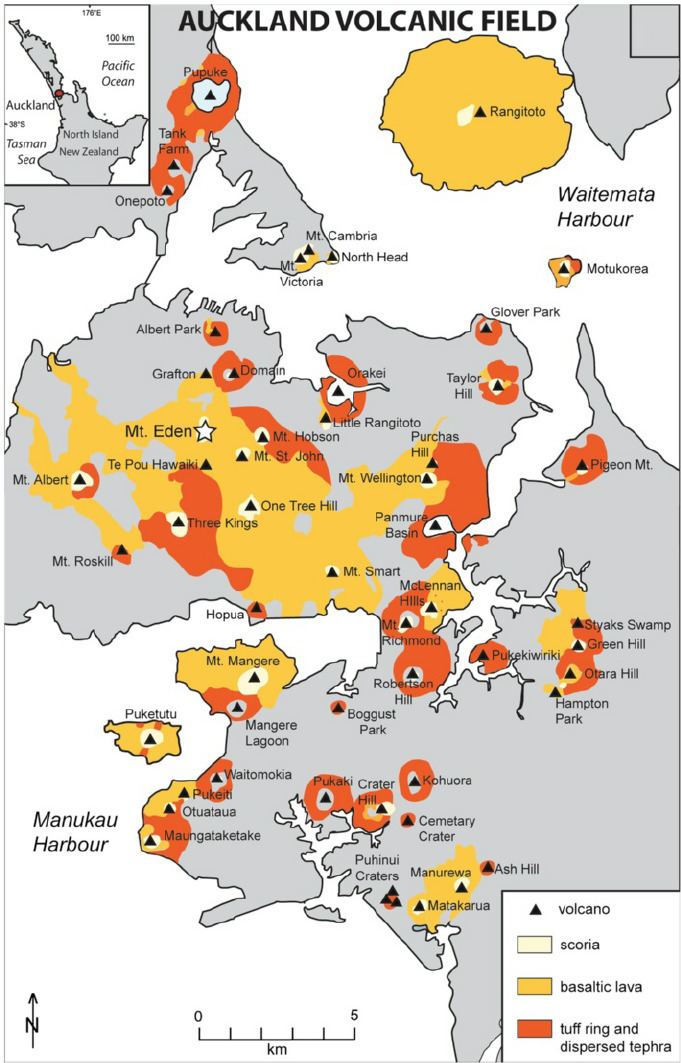
Lake Pupuke, on the North Shore near Takapuna, is a volcanic explosion crater. A few similar craters such as Orakei Basin are open to the sea.
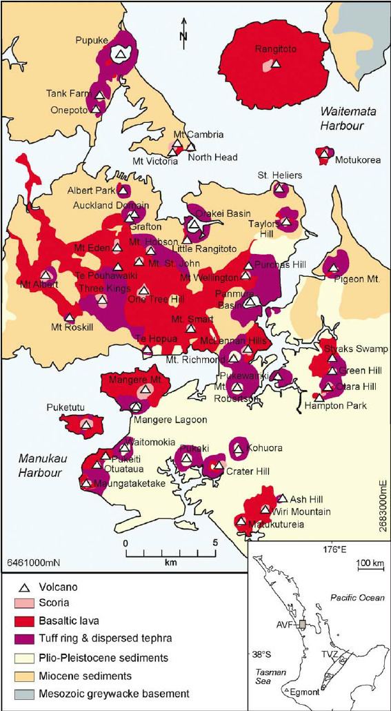
The field has produced voluminous lava flows that cover much of the Auckland isthmus. One of the longest runs from Mt Saint John northward, almost crossing the Waitemata Harbour to form Meola Reef. More than 50 lava tubes and other lava caves have been discovered, including the 290 metre long Wiri Lava Cave. The second longest individual cave in the Auckland field, some 270 metres (890 ft) in total length, is the Cave of a Thousand Press-ups to the east of One Tree Hill. Two impressive depressions caused by lava cave collapses are the Puka Street Grotto and the nearby Hochstetter Pond, also known as Grotto Street Pond, in Onehunga.
For most of the 250,000 years that the field has been erupting, the planet has been in glacial periods (ice ages) where sea levels were much lower due to water being locked up as ice, and the Waitemata and Manukau Harbours were dry land. All the volcanoes probably erupted on land except for Rangitoto, which erupted during the current interglacial (warmer) period.
Usage
Many of the volcanic cones were occupied by substantial Māori pa before European settlement, and many terraces and other archeological remnants are still visible. Many of the cones have been levelled or strongly altered – in small part due to the historical Māori use, but mostly through relatively recent quarrying of construction materials (especially scoria). However several of the remaining volcanoes are now preserved as landmarks and parks. The cones are also protected by a 1915 law, the Reserves and Other Lands Disposal and Public Bodies Empowering Act 1915, which was passed due to early concern that the distinctive landscape was being eroded, especially by quarrying. While often ignored until the late 20th century, it has amongst other things minimised severe changes to Mount Roskill proposed by Transit New Zealand for the Southwestern Motorway.
In March 2007, New Zealand submitted the volcanic field, with several specifically named features, as a World Heritage Site candidate based on its unique combination of natural and cultural features. At that time, only 2% of more than 800 World Heritage Sites worldwide were in this "mixed" category.
Dangers
Since the field is not extinct, new volcanic events may occur at any time, though the usual period between events averages between hundreds and thousands of years. However, the effects of such an event, especially a full-scale eruption, would be substantial – ranging from pyroclastic surges, earthquakes, lava bombs, ash falls, venting volcanic gas to lava flows. These effects might continue for several months and cause substantial destruction and disruption. These might range from burial of substantial tracts of residential or commercial property to mid-to-long-term closures of major parts of the country's infrastructure, such as the Port of Auckland, the State Highway network or the Auckland Airport. One possibility is that more than one volcano may erupt in Auckland at one time. There is strong evidence that five erupted within a span of 50 years or less, approximately 32,000 years ago.
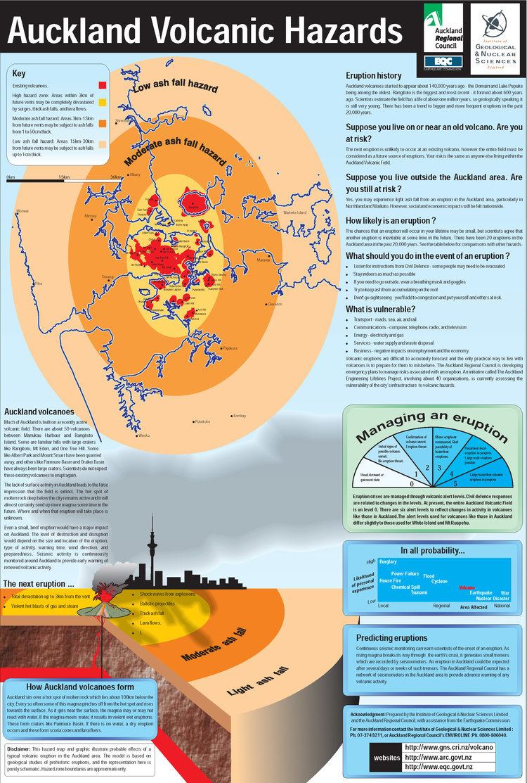
Various operative structures, plans and systems have been set up to prepare responses to volcanic activity within the urban areas, mainly coordinated in the 'Auckland Volcanic Field Contingency Plan' of the Auckland Regional Council, which provides a framework for interaction of civil defence and emergency services during an eruption. Auckland also has a seismic monitoring network comprising six seismometers (including one 250 m deep at Riverhead) and three repeaters within the Auckland Region that will pick up the small tremors likely to precede any volcanic activity. These tremors are likely to give some hours to some days of warning about an impending eruption and its approximate location.
Auckland Museum, itself built on the crater rim of Pukekawa, has an exhibition on the Auckland volcanic field, including the "Puia Street multi-sensory visitor experience" which simulates a grandstand view of an eruption in Auckland.
In 2013, scientists said new studies showed Rangitoto had been much more active in the past than previously thought, suggesting it had been active on and off for around 1000 years before the final eruptions around 550 years ago. Civil Defence officials said the discovery did not make living in Auckland any more dangerous, but did change their view of how an evacuation might proceed.
List of volcanoes
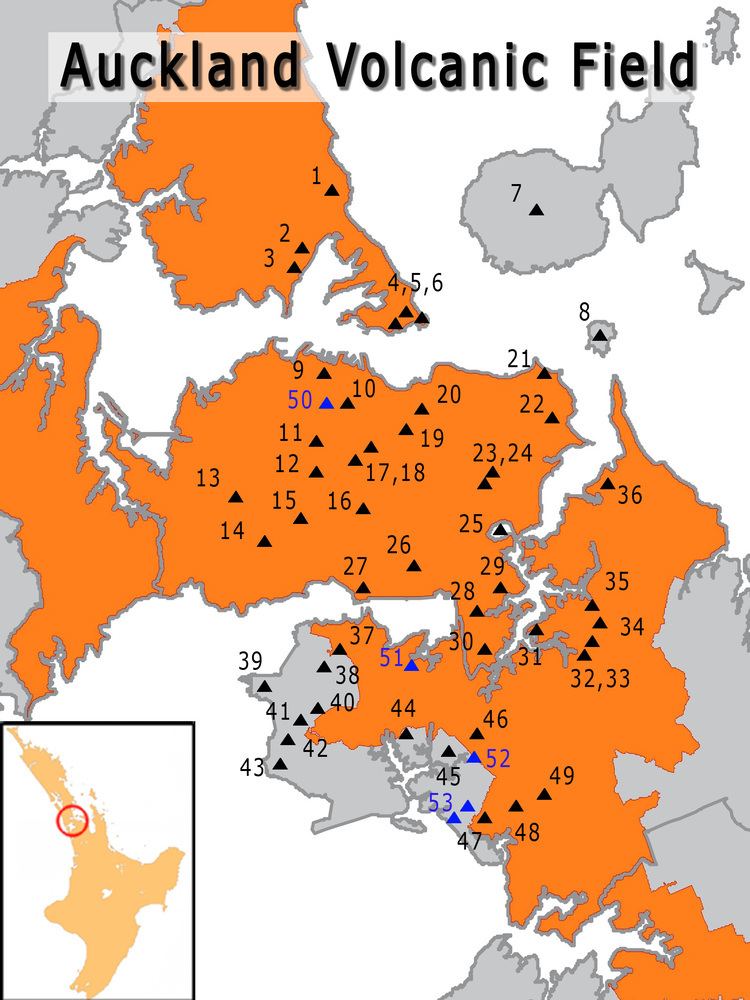
The volcanoes within the field are: