
- left Sawpit Creek - elevation 1,550 m (5,085 ft) - elevation 901 m (2,956 ft) | - location below South Rams Head - location Lake Jindabyne | |
 | ||
Sources Mount Leo, Snowy Mountains | ||
Thredbo river nsw fishing casting slow mo 2
The Thredbo River, a perennial river of the Snowy River catchment, is located in the Snowy Mountains region of New South Wales, Australia.
Contents
- Thredbo river nsw fishing casting slow mo 2
- Map of Thredbo River New South Wales Australia
- Course and features
- References
Map of Thredbo River, New South Wales, Australia
Course and features
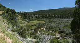
The Thredbo River rises below South Rams Head, near Mount Leo within the Kosciuszko National Park. The river flows generally adjacent to the Alpine Way, west and northwest near Dead Horse Gap, then generally north, passing through the village of Thredbo, joined by four tributaries including the Little Thredbo River, before emptying into Lake Jindabyne, impounded by Jindabyne Dam. Within Lake Jindabyne, the river reaches its confluence with the Snowy River.
The river descends 649 metres (2,129 ft) over its 40 kilometres (25 mi) course.
The flow of the river is impacted by alpine conditions; with high flows during spring as a result of snow melt. Meanwhile, during winter, the river is subject to snow and ice conditions.