
Population 22,965 (2011 census) Postcode(s) 6108 Area 11.6 km² Postal code 6108 | Established 1956 Founded 1956 | |
 | ||
State electorate(s) | ||
Thornlie is a large outer suburb of Perth, located 18 kilometres south-east of the city's central business district. It is part of the City of Gosnells local government area. The Canning River runs through the northern side of the suburb. Since the 1950s the suburb has developed in approximately five stages; north-east Thornlie (1950s-60s), south Thornlie (1970s-80s), Crestwood (1970s), Castle Glen (1980s) and Forest Lakes (1990s).
Contents
Map of Thornlie WA 6108, Australia
History
Captain Peter Pegus was the original settler of the area now known as Thornlie, which he had called "Coleraine" when granted the land in 1829. Prior to this the area would have been used by the indigenous Noongar population. In 1834 his premises and belongings were burned in a fire that was to prove the end of his settlement.
The name Thornlie was derived from a farm "Thornlie Park", established in 1884 by Frank and Amy James, Amy being a niece of Walter Padbury who financed the property.
The James family subsequently sold the estate, which had been a productive dairy farm, in 1937 to the mine-manager and investor, Nat Harper. When Harper died in 1954, the 694-hectare (1,715-acre) Thornlie estate was put up for auction in two lots. 92 hectares (228 acres) of Lot 1 were purchased by D. and M. O'Sullivan and by June 1956 the Gosnells Roads Board had provided approval for the development of the area. By March 1957, forty houses had been completed and by May 1958 there were 100 occupied homes. Thornlie thus as a residential suburb was established in the late 1950s as a housing estate aimed mainly at middle-income earners and inner city dwellers.
The first homes in the area included a section of residences constructed in the 1950s and early 1960s which lie to the north of the intersection of Thornlie Avenue and Spencer Road, and residences lying to the south of Thornlie Avenue between Spencer Road and the Canning River which were constructed in the 1960s and 1970s. During this time Thornlie development focus was on a getting out of town. It was aimed at inner city dwellers who might want to live in a more spacious semi-urban rural setting. It is one reason why Thornlie has typically large 1,000 m2 (1⁄4 acre) blocks and is often described as one of Perth's leafy suburbs.
The more upmarket Crestwood Estate, which was an experiment in providing fully integrated facilities and services to home-owners, was established from the early 1970s in the southern part of Thornlie, an experiment which was rarely replicated in later Perth subdivisions. From the 1980s the newer Castle Glen and Forest Lakes housing estates, which were at that time to some extent in competition with one another for land purchasers, were established in the remaining land in the western and south-western portions of Thornlie.. The focus of these developments was on providing affordable housing for new home buyers, generally young families.
Some semi-rural land in the western portion, mainly utilised for horse agistment and chicken-farming, was developed in the early 2000s. At one time there were several industrial activities taking place in the north-western portion. The last of these to close, about 2004, was the Ingham chicken-processing factory, the site of which was redeveloped for a residential estate.
Facilities
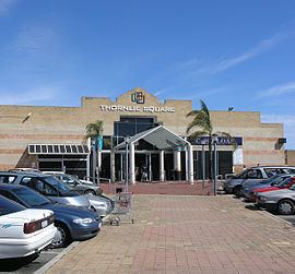
Thornlie is primarily a dormitory suburb with strong transport links to employment elsewhere in the metropolitan region. Albany Highway connects the suburb to the CBD, Roe Highway links it the regional road network, bus services are fairly frequent and a passenger rail service terminates at Thornlie railway station. Retail services are provided through local and neighbourhood centres the largest of which is Thornlie Square Shopping Centre (1970s) and the Forest Lakes Forum (1990s). A range of sporting facilities are available for community usage include lawn Bowls, tennis courts, a skate park, swimming pool, gyms and ovals for cricket and football. Baseball Park, built in 2007, is the home of Perth Heat, a team in the Australian Baseball League.
Community
Thornlie has two local papers distributed fortnightly, The Comment News and the Gosnells Examiner. 107.3 Heritage FM is a volunteer run Radio station for Thornlie and the Shire of Gosnells as a whole. Community programmes include the annual Safe City awards including the Community Initiative Award, the Constable Peter Ball Memorial Youth Award and the Community Kids Award.
Demographics
The percentage of residents born overseas (39.4%) is greater than both the national (27%) and metropolitan (31.3%) average. 11.3% of residents were born in England; 3% in New Zealand, and significant smaller percentages from Malaysia, India and Scotland. 14% of residents speak a language other than English at home. Unemployment (3.4%) is lower than the regional average (3.7%) and socio-economic disadvantage less than the City of Gosnells as whole. Weekly household incomes are characterised by a lower proportion of both low and higher income households compared with the Perth average. There are no major differences between the religious affiliation of Thornlie and the Perth region as a whole. The dominant religion is Catholicism (22.4%) followed by Anglicanism (19.5%), Islam (4.6%) and Buddhism (3.5%). Since 2001 there has been a mild decline in the number of Catholics and Anglicans and an increase in the number of Muslims, by 2002 Thornlie had the highest population of Muslims in Perth.
Crestwood Estate
Thornlie contains Crestwood Estate, a residential subdivision still noted for its successful implementation of the Radburn design principles. Original Radburn architect Clarence Stein reportedly described it as the 'first perfect Radburn scheme in the world' and from 1973 to 1976 it received both national and international recognition. Whilst the Radburn principles flavoured many other post-war developments across Australia including the Perth suburbs of City Beach and Karawara, it remains one of the few suburbs that has not undergone a sustained process of 'de-Radburnisation' since the 1990s. From a heritage perspective Crestwood is a highly significant link to a major twentieth century urban design movement.
Crestwood was based on the ideas of Paul Ritter, Perth's first and somewhat controversial city planner. Ritter had spent many years advocating the idea that "it takes a village to raise a child". One of his lectures on creating innovative urban environments to meet the needs of family and community life captured the imagination of property developer Ron Sloan. Together Sloan, Paul Ritter and planner Hugh Reynolds designed a residential estate according to a strict design brief.
Crestwood was to be equally efficient and economical as a conventional subdivision, with the same density of homes (8.2/ha or 3.3/acre), but 8% additional open space. Every house was to face a park and roads were to be designed to limit the speed of vehicles. There was to be passive surveillance of recreational areas, and pedestrian traffic through the estate was to be separated from vehicular. Each house was individually designed, some through a design competition organised by the Institute of Architects.
Originally, Crestwood was intended to be built to about five times the size that was eventually constructed. It was to be built around a large pool complex with administration buildings and a recreational area. However, the collapse of land values in the early 1970s led to slow takeup of the allotments and significant losses for Sloan. The subdivision never progressed as envisioned and the land was used in the 1980s and 1990s for two more conventional subdivisions, Forest Lakes and Castle Glen Estates.