
Country United States County Delaware Elevation 335 ft (102 m) Population 8,028 (2010) Local time Thursday 10:05 PM | Established 1685 Time zone EST (UTC-5) Area code Area codes 610 and 484 | |
 | ||
Weather 7°C, Wind SE at 10 km/h, 67% Humidity Points of interest Thornbury Park, Palmer Arboretum, Thornton Village Historic District | ||
Thornbury Township is a township in Delaware County, Pennsylvania, United States. The population was 8,028 at the 2010 census, up from 7,093 at the 2000 census. It is adjacent to, and was once joined with, Thornbury Township, Chester County, Pennsylvania.
Contents
- Map of Thornbury Township PA USA
- Geography
- Demographics
- History
- Government and infrastructure
- Education
- Community
- References
Map of Thornbury Township, PA, USA
Geography
Thornbury Township is in western Delaware County, northwest of Chester and southeast of West Chester. According to the United States Census Bureau, the township has a total area of 9.3 square miles (24.0 km2), of which 9.2 square miles (23.9 km2) is land and 0.04 square miles (0.1 km2), or 0.34%, is water.
Demographics
As of the census of 2000, there were 7,093 people, 1,360 households, and 1,153 families residing in the township. The population density was 769.1 people per square mile (297.0/km²). There were 1,387 housing units at an average density of 150.4/sq mi (58.1/km²). The racial makeup of the township was 64.68% White, 31.09% African American, 0.11% Native American, 1.27% Asian, 0.06% Pacific Islander, 2.10% from other races, and 0.69% from two or more races. Hispanic or Latino of any race were 2.72% of the population.
There were 1,360 households, out of which 44.5% had children under the age of 18 living with them, 77.9% were married couples living together, 4.9% had a female householder with no husband present, and 15.2% were non-families. 12.1% of all households were made up of individuals, and 5.8% had someone living alone who was 65 years of age or older. The average household size was 3.03 and the average family size was 3.33.
In the township the population was spread out, with 27.7% under the age of 18, 20.5% from 18 to 24, 27.5% from 25 to 44, 18.0% from 45 to 64, and 6.2% who were 65 years of age or older. The median age was 27 years. For every 100 females there were 172.9 males. For every 100 females age 18 and over, there were 160.5 males.
The median income for a household in the township was $82,441, and the median income for a family was $91,179. Males had a median income of $65,671 versus $36,750 for females. The per capita income for the township was $21,987. About 0.9% of families and 14.2% of the population were below the poverty line, including 0.8% of those under age 18 and 2.0% of those age 65 or over.
History
Thornbury Township lies in the drainage area of the Delaware River, named in honor of Thomas West, 3rd Baron De La Warr, governor of the colony of Virginia. The river and its bay were explored by Henry Hudson in 1609, and over the next several decades the region was variously claimed by the Swedes, the Dutch, and the English. Its original human inhabitants were the Lenni-Lenape tribe of American Indians.
Once the Dutch were defeated, King Charles II of England made his grant to William Penn in order to found the colony which came to be named Pennsylvania. The land within the present boundaries of Thornbury Township was taken up by "first purchasers" from William Penn. The original grant documents were copper-plate prints on parchment; some still survive and show a price of 100 English pounds for 5,000 acres (2,000 ha).
The Court of Equity in Chester recognized a separate Thornbury Township in 1687, and appointed township officers. At the time, the area was in Chester County, one of the original counties chartered by William Penn; Delaware County had not yet been formed. Thornbury was named after the English birthplace of the wife of George Pearce, who in 1685 had been granted title to 490 acres (200 ha) in the township.
The Battle of Brandywine, the only major battle of the American Revolution fought in Pennsylvania, was within sight and sound of the western part of the township; follow-up military operations took place in the township (see below).
In 1769, the Pennsylvania Assembly authorized the division of Chester County and the creation of Delaware County. In plotting the boundary between the two, Thornbury Township was divided. Border landowners were asked if they wished to remain in Chester County or be in Delaware County. The line thus drawn was quite irregular, and as a result, the northern boundary of the Delaware County township (like the southern boundary of its Chester County counterpart) is distinctly jagged (see map).
Thornbury Township was enlarged by annexing the northern portion of Aston Township in 1837; that township was dissolved. The boundaries of Thornbury have remained unchanged since.
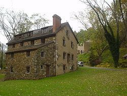
The township is the location of "Thornbury" house, home of Revolutionary War figure Persifor Frazer. After the Battle of Brandywine, his wife Mary stood down a British raiding party in a celebrated incident. The house and barn survived the war, but are now in ruins.
The Chester Creek Historic District and Thornton Village Historic District are listed on the National Register of Historic Places.
Government and infrastructure
The George W. Hill Correctional Facility (Delaware County Prison), operated by Community Education Centers, is located in the township.
Education
Cheyney University of Pennsylvania is partially located in Thornbury Township, Delaware County, and partially in Thornbury Township, Chester County.
Community
Glen Mills Schools, a residential facility for male juvenile delinquents, is in Thornbury Township.