
Country Thailand Khwaeng 7 Postal code 10600 Province Bangkok | Seat Bang Yi Ruea Time zone ICT (UTC+7) Area 8.551 km² Geocode 1015 | |
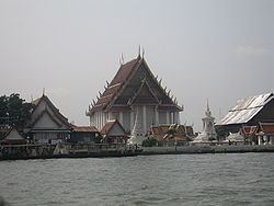 | ||
Thon Buri (Thai: ธนบุรี; [tʰōn būrīː]) is one of the 50 districts (khet) of Bangkok, Thailand. On the west bank of Chao Phraya River, it was once part of Thon Buri Province. Neighboring districts are (from north clockwise) Bangkok Yai, Phra Nakhon (across Chao Phraya River), Khlong San, Bang Kho Laem (across Chao Phraya), Rat Burana, Chom Thong, and Phasi Charoen.
Contents
History
The district used to be called Amphoe Ratchakhrue (ราชคฤห์) due to a nearby wat of the same name. It was renamed Amphoe Bang Yi Ruea on 11 July 1916 (after the location of the new amphoe office), and finally to Thon Buri on 17 April 1939. The district then belonged to Thon Buri Province. In December 1971 the province was merged with Bangkok to form the present day Bangkok metropolitan area.
Places
Shopping
Transportation
Administration
The district is divided into seven sub-districts (kwaeng).