
Age Mesozoic Province British Columbia | Highest point Skoatl Point Country Canada | |
 | ||
Mountains Mount Boucherie, Skoatl Point, Stockton Hill Passes Pennask Summit, Clapperton Creek Summit | ||
The Thompson Plateau, also known as the Okanagan-Thompson Plateau, forms the southern portion of the Interior Plateau of British Columbia, Canada, lying to the west of Okanagan Lake, south of the Thompson River and to the east of (although never adjoining it) the Fraser River. At its most southern point the plateau is squeezed by the mountainous terrain of the Cascade Range abutting closer to the Okanagan Valley. Its southwestern edge abuts the Canadian Cascades portion of that extensive range, more or less following the line of the Similkameen River, its tributary the Tulameen River, and a series of passes from the area of Tulameen, British Columbia to the confluence of the Thompson River with the Nicoamen River, a few miles east of Lytton, British Columbia, which is in the Fraser Canyon. Its northeastern edge runs approximately from the city of Vernon, British Columbia through the valley of Monte Creek to the junction of the same name just east of the city of Kamloops. Northeast of that line is the Shuswap Highland.
Contents
Map of Thompson Plateau, Thompson-Nicola M, BC, Canada
Some definitions include the Bonaparte Plateau to the north, which lies in the angle of the Thompson and Bonaparte Rivers, and south of the uppermost reaches of that river and a small tributary of the North Thompson, Lemieux Creek.
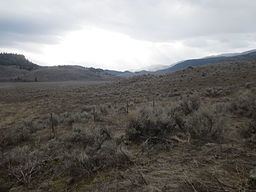
The dominant landscape of the Thompson Plateau is a high, almost plains-like rangeland fairly heavily forested with subalpine forest and tamarack swamp where there exists a significant cattle ranching industry, but plunging steeply to the valleys of the Thompson and Okanagan on its outer perimeter which feature more semi-arid landscapes that include rattlesnakes, a ground-creeping variety of prickly pear cactus, sagebrush, and tumbleweed, in addition to fruit growing operations that often rely on irrigation. In its core is the broad and open rangeland of the Nicola Valley, at the focus of which is the town of Merritt, British Columbia. Towards its southern edges, the plateau is fairly mountainous and includes the ski area at Apex (west of Penticton), as well as the small but rugged Kruger Range which runs south from there to the confluence of the Similkameen and Okanagan Rivers.
HistoryEdit
The Thompson Plateau contains Nicola Athapaskan, Nlaka'pamux and Syilx settlements. The Nlaka'pamux peoples of the plateau were known as Cawa'xamux or Tcawa'xamux
Nlaka'pamux settlements include:
Syilx settlements include:
GeologyEdit
The rocks underlying the Thompson Plateau originated in the Pacific and were appended to the North American Plate in the Mesozoic. These rocks were pervasively intruded by magmas now forming granitic rocks. These upland surfaces are now bordered by prominent valleys over 1000 metres deep. This peneplain was overlain by thin sheets of plateau basalts formed from the Chilcotin Group lavas that flowed ten to fifteen million years ago.
The area was occupied by Pleistocene glaciation, and a thick mantle of glacial drift covers bedrock over a large part of it. The Pleistocene ended with a gradual stagnation and a wasting of the ice in place. As a consequence, on many slopes a series of channels was formed at successive levels as ice surfaces wasted.