
Topo map USGS Thompson Peak Prominence 1,193 m Parent range Klamath Mountains | Elevation 2,744 m Parent peak Mount Eddy | |
 | ||
Location Trinity County, California, U.S. Mountain range Cascade Range, Trinity Alps, Klamath Mountains Similar Granite Peak, Russian Peak, Mount Eddy, Preston Peak, Salmon Mountain | ||
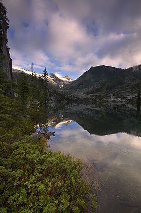
Thompson Peak is a mountain (a high point on a tall granite ridge) in Trinity County, California. It is the highest peak in the Trinity Alps Wilderness. It is the highest point in a ridge that also features Wedding Cake, another well-known Trinity Alps peak. Thompson Peak is the highest Peak in the Trinity Alps Wilderness, a vast assemblage of craggy granite mountains in northwestern California (Trinity Alps Wilderness is the seventh largest designated wilderness area in California). Thompson Peak is the second highest mountain in Northern California west of the Cascades, after 9027 foot; Mount Eddy. (Quote from Per SP member Ed Cooper) "It is incorrect to say that there is no longer glacial activity in the area. The Thompson Glacier lies below the North Face of Thompson Peak. Late in the season, when most of the winter snow has melted, the crevasses and ice of this glacier are exposed. There is another smaller body of snow/ice to the right of the Thompson Glacier, below the north face that might also be considered a small glacier. Further, there is definitely one small glacier on a nearby peak that has crevasses and clearly displays glacier ice. The Trinity Alps have the distinction of being the only mountain range in the United States that lies entirely below timberline (small trees grow just below the final summit block of Thompson Peak) that contains active glaciers." Thompson Peak has steep north and east faces and a gentle southwest slope. Permanent snow fields fill its wide north cirque and also below its east face. It is usually climbed from Canyon Creek Trail, ascending the class 2-3 South Ridge from the east. This route has an 8000 feet elevation gain. About 10 miles.