
 | ||
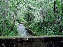
The Rythe is a river or stream in north Surrey, England which is generally open and which is a natural woodland feature for approximately half of its course before being variously culverted and a suburban garden feature, passing between Thames Ditton and Long Ditton, then discharging into the Thames, its longest branch is the Arbrook which drains Arbrook Common, a woodland of the mainly wooded Esher Commons.
CourseEdit
The Rythe or Wrythe rises at several sources, the furthest being four sources in Prince's Coverts (woodland), all in the parish and ward of Oxshott where on its northern edge it combines to form the Arbrook.
It runs under the six-lane A3 into wooded Arbrook Common there joined by three further headwaters rising in the suburban area of adjoining Claygate immediately to the east (right bank). It carries on north bounding Littleworth Common and Hinchley Wood to the Scilly Isles roundabout at part of remnant wooded Ditton Marsh, today cast colloquially and locally as a part of Esher, being close to Esher railway station and in that post town. It then follows the Portsmouth Road (SW from London) west through part of Thames Ditton proper and alongside the South Western Main Line. It receives its shorter east branch (rising in Surbiton Golf Course, Long Ditton within Elmbridge) then turns forming the boundary between Long Ditton, (here in Surbiton post town and Elmbridge, Surrey) and Thames Ditton, running into the Thames near Ferry Road heading 800 north.
The Rythe has often clay-lined banks and its lack of depth and width in places, as opposed to its historic condition, has been implicated in flash flooding in a few gardens and drainage systems, particularly for its mid-course headwaters in the suburban central part of Claygate. A flood alleviation scheme was therefore drawn up in 2002 between the responsible authorities. It discharges into the Thames between Thames Ditton and Long Ditton on the reach above Teddington Lock on the north-western border of the county with the edge of the administrative county of London. It marks the traditional border of the parish of Thames Ditton and Long Ditton but under the headline post town of the early-20th settled UK addressing system is almost wholly in Thames Ditton.