
 | ||
The National Map is a collaborative effort of the United States Geological Survey (USGS) and other federal, state, and local agencies to improve and deliver topographic information for the United States. The purpose of the effort is to provide "...a seamless, continuously maintained set of public domain geographic base information that will serve as a foundation for integrating, sharing, and using other data easily and consistently".
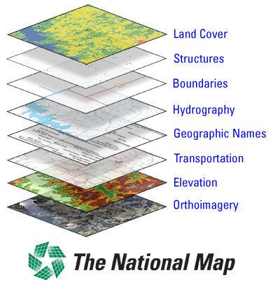
The National Map is part of the USGS National Geospatial Program. The geographic information available includes orthoimagery (aerial photographs), elevation, geographic names, hydrography, boundaries, transportation, structures and land cover. The National Map is accessible via the Web, as products and services, and as downloadable data. Its uses range from recreation to scientific analysis to emergency response.
The National Map is a significant contribution to the National Spatial Data Infrastructure (NSDI) and currently is being transformed to better serve the geospatial community by providing high quality, integrated geospatial data and improved products and services including new generation digital topographic maps. In addition, the National Map is foundational to implementation of the U.S. Department of the Interior (DOI) Geospatial Modernization Blueprint.
The USGS also utilizes data from The National Map Corps, which consists of volunteers who devote some of their time to provide cartographic information on structures.
The National Map is the official replacement for the USGS topographic map program.