
Elevation 820 m | ||
 | ||
Similar Mount Brown Conserva, Heysen Trail, Pichi Richi Railway, Mount Remarkable National, Wilpena Pound | ||
Australia in the dutchmans stern conservation park
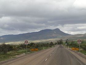
The Dutchmans Stern is a mountain in South Australia located in the Flinders Ranges about 5 kilometres (3.1 mi) north-west of the town of Quorn and 25 kilometres (16 mi) north east of the city of Port Augusta. The mountain was named due to its “supposed resemblance to the stern of a Dutch vessel” with one source attributing the naming to early settlers in the vicinity while another source gives attribution to the British navigator, Matthew Flinders.The mountain has a height of 820 metres (2,690 ft). Since 1987, it has been located within the boundaries of the protected area known as the The Dutchmans Stern Conservation Park where its “prominent bluff“ is considered to be “the main feature” of the conservation park. The mountain’s summit can be reached via a walking trail known as “The Dutchmans Stern Hike” which starts in the carpark at the entrance of the conservation park to the north east of the summit and which is reported by the conservation park’s managing authority as consisting of a loop which allows two choices of route - one being a walk of the full loop with a distance of 10.5 kilometres (6.5 mi) and a return time of 5 hours while the other is the most direct path to the summit with a total distance of 8.2 kilometres (5.1 mi) and a return time of 4 hours.
Contents
- Australia in the dutchmans stern conservation park
- Map of The Dutchmans Stern Quorn SA 5433 Australia
- The dutchmans stern
- References