
PIN 680 028 Local time Thursday 7:07 PM | Time zone IST (UTC+5:30) Telephone code 91 (0)487 69 | |
 | ||
Weather 31°C, Wind W at 13 km/h, 70% Humidity | ||
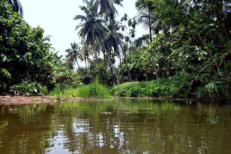
Thanikkudam (Malayalam: താണിക്കുടം) is a rapidly growing suburb north-east of Thrissur, in the Indian state of Kerala. The village-town is home to the Thanikkudam Bhagavathi Temple which is popularly known across the central part of Kerala. A small river, which has become perennial in recent times stretches through the middle of the village, oriented in a north-east to South-west direction. The area is also wound around by the Right Branch Main Canal (RBMC) of the Peechi hydro-irrigation project system.
Contents
- Map of Thanikkudam Kerala
- Geography and Landscape
- Geography
- People
- Agriculture
- Thanikkudam Temple
- References
Map of Thanikkudam, Kerala
Geography and Landscape
The geography and landscape of Thanikkudam is very typical of the middle-land villages of Kerala, and in particular that of Thrissur district. The land has an overall inclination along the North East to South west direction. This significantly affects the hydrology, precipitation, water drainage and wind flows.
The village shares its eastern border at Chenkalli, a hill of heights up to 1000m above sea level with the south-western tips of Vazhani range and north-western slopes of Peechi and Vellani mountains. Except for a few more hillocks such as Meppadam and Thaliyanpara, the land has a generally plain nature with intermediate undulating profiles.
The populated areas have altitudes ranging from 15m to 30m above sea level.
The village has a multitude of soil types such as laterite, clay, alluvial slits and gravel.
Geography
The protected natural forests lining the eastern borders and neighboring high ranges provide for satisfactory precipitation. The drainage is relatively retarded by the natural undulations and mixture of high and low terrains.
The short and narrow Thanikkudam river divides the village into two areas. Beginning from the slopes of Vazhani ranges and Chenkalli, the river has become mostly perennial over the last few decades owing to the change in climate and land use. However, it has important effect on the lifestyle, water use and weather of the place.
People
The population consists of lower and upper class middle class with comparable economic and educational levels of other parts of Kerala. The majority belong to Hindu religion. Up to 5% of the people are Christians. Other religions are insignificantly lower in population. The common language is Malayalam. However, due to a large number of villagers who have been working in the past or at present at remote places (such as middle east or other parts of India), people who can manage English, Hindi, Tamil, Telugu and Arabic can be seen among them.
Agriculture
Forest was cleared and farming started in the famine period of 1940s. The Thanikkudam river divides the village into two parts. The Right Branch Main Canal road goes around the village.
Thanikkudam Temple
There is an Upper Primary School, a village Library and several governmental service institutions which serve the village as well as her neighbors. Both the school and library have been in existence since more than 50 years ago and have been effective in raising the educational and social welfare of the inhabitants. Although the area was predominantly agricultural in nature (especially rice, rubber and cashew), the recent trends have reduced and replaced those crops to Banana plantain, horticulture etc. The increasing inrush of more inhabitants has reduced the available land for cultivation. Besides, the water resources are no longer sustainable over an annual period to support full-fledged agriculture.