
Country Thailand Area 611.8 km² Postal code 82120 Geocode 8208 | Time zone THA (UTC+7) Population 45,547 (2000) Province Phang Nga Province | |
 | ||
Thai Mueang (Thai: ท้ายเหมือง) is a district (amphoe) in the province Phang Nga in the south of Thailand.
Contents
Map of Thai Mueang District, Phang Nga, Thailand
Geography
Neighboring districts are (from the north clockwise) Takua Pa, Kapong, Mueang Phang Nga and Takua Thung. To the west is the Andaman Sea.
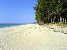
The Khao Lampi–Hat Thai Mueang National Park was established in 1986 and covers 72 km². The park consists of two parts: the beach of Thai Mueang as well as the natural rain forest at Lampi mountain.
Administration
The district is subdivided into 6 subdistricts (tambon), which are further subdivided into 40 villages (muban). Thai Mueang itself has township (thesaban tambon) status. There are 6 Tambon administrative organization (TAO).
References
Thai Mueang District Wikipedia(Text) CC BY-SA