
Purpose Multi-purpose Opening date 1981 | Location Kanchanaburi Province Status Operational | |
 | ||
Similar Lam Takhong Dam, Chulabhorn Dam, Pak Mun Dam, Bang Lang Dam, Sirindhorn Dam | ||
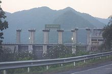
The Tha Thung Na Dam (Thai: เขื่อนท่าทุ่งนา) is a multi-purpose hydroelectric dam in the Mueang District of Kanchanaburi Province, Thailand. It impounds the Khwae Yai River. The dam is located at the southeastern corner of Erawan National Park.
Contents
Description
Tha Thung Na Dam is a rock fill and concrete gravity dam. It is 840 m (2,760 ft) long and 30 m (98 ft) high. Its reservoir has a maximum storage capacity of 710,000,000 m3 (2.5×10¹⁰ cu ft).
Power plant
The dam's power plant has two hydroelectric generating units, each with an installed capacity of 19 MW. The first unit was commissioned in December 1981 and the second unit in February 1982.
References
Tha Thung Na Dam Wikipedia(Text) CC BY-SA