
Country Thailand Time zone THA (UTC+7) Area 1,055 km² Province Chachoengsao Province | Seat Tha Takiap Postal code 24160 Population 45,926 (2015) Geocode 2410 | |
 | ||
Tha Takiap (Thai: ท่าตะเกียบ) is the easternmost district (Amphoe) of Chachoengsao Province, central Thailand.
Contents
- Map of Tha Takiap District Chachoengsao 24160 Thailand
- History
- Geography
- Central administration
- Local administration
- References
Map of Tha Takiap District, Chachoengsao 24160, Thailand
History
The minor district (King Amphoe) Tha Takiap was established on April 1, 1991 by splitting off two tambon from Sanam Chai Khet district. It was upgraded to a full district on December 5, 1996.
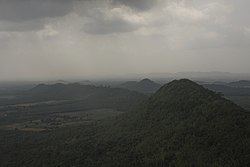
Geography
Neighboring districts are (from the north clockwise) Sanam Chai Khet of Chachoengsao Province, Khao Chakan, Wang Nam Yen and Wang Sombun of Sa Kaeo Province, Kaeng Hang Maeo of Chanthaburi Province, and Bo Thong and Ko Chan of Chonburi Province.
Central administration
The district Tha Takiap is subdivided into 2 subdistrict (Tambon), which are further subdivided into 47 administrative villages (Muban).
Local administration
There are 2 subdistrict administrative organizations (SAO) in the district: