
Existed: 1939 – present Constructed 1939 | Length 76.83 km | |
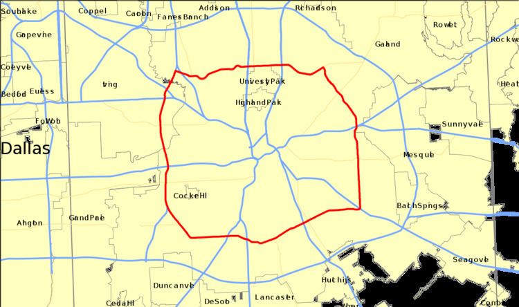 | ||
Loop 12 is a state highway that runs mostly within the city limits of Dallas, Texas. The western segment of the loop is named after General Walton Walker who served and died in South Korea. During the 1950s and 1960s, Loop 12 was the outer beltway in the Dallas area, having since been supplanted by Interstate 635, which is itself being supplanted by the President George Bush Turnpike (SH 190). Loop 12 is, however, the only state highway in Dallas that forms a complete loop (Belt Line Road is also a complete loop but is not a state road except for a stretch as part of Farm to Market Road 1382).
Contents
Map of TX-12 Loop, Dallas, TX, USA
Route description
Starting in the east at Interstate 30, Loop 12 goes north as Buckner Boulevard, following surface streets past White Rock Lake. Just north of White Rock Lake, it intersects Spur 244 and becomes Northwest Highway to the west; because there is an eastern and a western segment to this part of the road, at certain points the road signs read "East Northwest Highway." It continues west along surface streets over Central Expressway (US 75) and the Dallas North Tollway and moves north of Bachman Lake and Dallas Love Field.
After crossing Interstate 35E, Loop 12 moves south as a freeway, locally known as Walton Walker Boulevard, passing where Texas Stadium once sat at the interchanges with State Highways 114 and 183. The segment between I-35E (Stemmons Freeway) and Spur 408 is the only portion of Loop 12 that is freeway. It is also the only portion that leaves the Dallas city limits, as it runs through the eastern portion of Irving between where the road crosses the Elm Fork of the Trinity River (northern boundary, just north of the former site of Texas Stadium) and where it crosses the West Fork of the Trinity River (southern boundary).
After intersecting Interstate 30 for the second time, Loop 12 continues south, joining surface streets again west of Mountain Creek Lake at Mountain Creek Parkway and Patriot Parkway (or Spur 408, which provides a southwesterly freeway link to I-20). It continues to the southeast, turning east along Ledbetter Drive, just north of Dallas Executive Airport (formerly Red Bird Airport). It continues east, crossing US 67, Interstate 35E for the second time and Interstate 45. At the intersection with US 175 and Murdock Road, Loop 12 turns north again as Buckner Boulevard all the way back to Interstate 30. The portion between Bonnie View Rd. and US 175 is also known as Great Trinity Forest Way as it passes across an undeveloped portion of the Trinity River and the Trinity River Audubon Center.
Major intersections
The entire route is in Dallas County.