
Existed: 1946 – present Length 27.14 km | Constructed 1946 | |
 | ||
East end: Corpus Christi Naval Air Station | ||
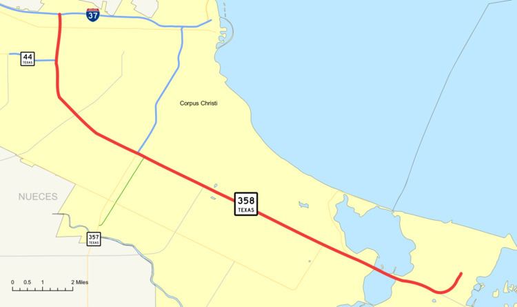
State Highway 358 or SH 358 is a Texas state highway that runs along the southern edge of Corpus Christi. The route was designated in 1946 from SH 286 to the Naval Air Station, replacing FM 693. It was extended northwest to Interstate 37 in 1958, replacing FM 891. It is also known as Padre Island Drive with both North and South sections. Known to the locals as "N.P.I.D." and "S.P.I.D.", the dividing line is commonly believed to be Texas State Highway 286. The official division is FM 665 (Old Brownsville Road).
Contents
Map of TX-358, Corpus Christi, TX, USA
History
The section of the highway from SH 286 east to Corpus Christi Naval Air Station was originally designated as FM 693 in June 1946. In September of that same year, it was redesignated to SH 358. The section from SH 286 northward to I-37 (SH 9 at the time) was originally designated as Farm to Market Road 891 in 1948 and was combined with the current route in 1958.
Route description
SH 358 is located in Corpus Christi in Nueces County and begins at I-37 near Nueces Bay and ends at the Corpus Christi Naval Air Station on the south side of Corpus Christi Bay. SH 358 is a freeway that follows Padre Island Drive and provides access to Padre and Mustang Islands by way of Park Road 22 (PR 22).
The freeway begins at an interchange with I-37 west of the bayfront area of Corpus Christi. It heads south from the interchange to an interchange with SH 44 which provides access to Corpus Christi International Airport. It continues to the south and begins to turn to the southeast just prior to a junction with FM 665 (Old Brownsville Road). The highway continues to the southeast to an interchange with SH 286 (Crosstown Expressway). The freeway continues to the southeast through the city to a junction with SH 357 (Rodd Field Road) just prior to Oso Bay. After crossing the bridge over Oso Bay, the freeway heads southeast to an interchange with PR 22. PR 22 continues to the southeast over the John F. Kennedy Memorial Causeway to Padre Island as SH 358 curves to the northeast to its eastern terminus at the Corpus Christi Naval Station.
Future
As far as 2007, SH 358 is currently undergoing major improvements to four miles (6 km) of its roadway from its interchange with SH 286 to Airline Road in Corpus Christi. The traffic volumes along South Padre Island Drive are at an all-time high with an average daily traffic count of 153,430 vehicles in 2005. The roadway construction project consists of ramp reversals and adding auxiliary lanes to the roadway.
Exit list
The entire highway is in Corpus Christi, Nueces County.