
Existed: 1956 – present Length 25.18 km | Constructed 1956 | |
 | ||
East end: Bluewater Highway in Surfside Beach | ||
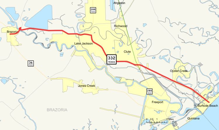
State Highway 332, abbreviated SH 332, is a 15.646-mile (25.180 km) state highway in the U.S. state of Texas. The highway includes a 4.8 mi (7.7 km) concurrent section with SH 288 that brings the total length to 20.4 miles (32.8 km). The highway begins at a junction with State Highway 36 (SH 36) in Brazoria and heads east to a junction with the Bluewater Highway in Surfside Beach.
Contents
Map of TX-332, Texas, USA
History
SH 332 was originally designated in 1939 as the bridge over the Intercoastal Canal. In 1950, it was redesignated and combined with FM 1460 which had been designated a year earlier to from the bridge to FM 523. In 1954, the eastern terminus was extended to an intersection with the Bluewater Highway, while the western terminus was extended to FM 521 when FM 1605 was combined with the route. In 1956, the route was redesignated to SH 332 and the western end was extended to SH 36 replacing FM 521.
Route description
SH 332 begins at a junction with SH 36 in Brazoria. It heads east from this junction to an intersection with FM 521. The highway continues to the east to an intersection with FM 2004 in Lake Jackson. Heading towards the east, the highway continues to an intersection SH 288. The highway intersects SH 288. It continues to the east to a junction with Business 288 in Clute. As the highway continues to the east, it intersects FM 523. SH 332 reaches its eastern terminus at the Bluewater Highway in Surfside Beach.
Junction list
The entire route is in Brazoria County. All exits are unnumbered.