
Existed: 1958 – present SH 88 SH 89 → Constructed 1958 | Length 134.4 km | |
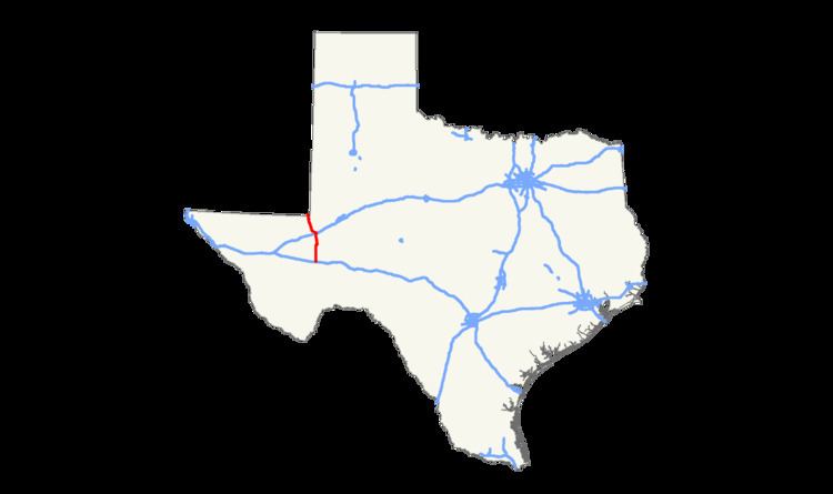 | ||
State Highway 18, or SH 18, is a state highway in the U.S. state of Texas maintained by the Texas Department of Transportation (TxDOT) that runs from Fort Stockton in western Texas to the Texas-New Mexico state line between Kermit and Jal, New Mexico. This route was designated in 1958 over the northern half of what was previously SH 82.
Contents
Map of TX-18, Texas, USA
Route description
SH 18 begins at Fort Stockton at an intersection with Business Interstate 10 and US 285. Heading north, it soon intersects Interstate 10 and US 67, which is in concurrency with the interstate. It continues traveling north through oil fields and rural ranch land. 25 miles north of Fort Stockton, SH 18 intersects Farm to Market Road 1450. The highway continues north and enters Grandfalls. In Grandfalls, the highway intersects SH 329 and Farm to Market Road 11. The highway continues north, intersecting Farm to Market Road 1776, Farm to Market Road 1233, Loop 464, and Interstate 20 before reaching Monahans. In Monahans SH 18 intersects Business Interstate 20 and continues northwest, making a second interchange with SH 464. Eight miles northwest of Monahans, the highway intersects Farm to Market Road 1219. SH 18 continues in a slightly northwest direction toward Kermit, making an interchange with Farm to Market Road 1232 along the way. In Kermit the highway has an intersection with SH 302 and a slight western concurrency with SH 115 before continuing to head northwest out of Kermit. The highway ends at the New Mexico border, where the road becomes New Mexico State Highway 18.
History
The current routing was originally planned as State Highway 17 as recently as 1922. By 1926, the SH 17 designation has been transferred to the routing of SH 17A, while this route was renumbered as SH 82. In 1958, the route was again renumbered as SH 18, to coordinate with the connecting New Mexico Highway 18 to the north.
SH 18 was one of the first 26 Texas state routes proposed in 1917. The original proposal was a route through the Southern Plains from Yoakum County to Lubbock, then southeast to Albany. By 1926, the route had been changed significantly. The eastern section of the route from Spur to Albany was intact, but the previous westward route veered northward instead to Estelline. By 1939 it was extended farther northward to Pampa, overtaking SH 88 from Turkey to Pampa, while the portion from Matador to Albany was reassigned to various state highways and U.S. Highway 380. SH 18 was extended further north to Perryton in 1940, and in 1947 was renamed SH 70 when SH 70 was extended into Matador from the south.
SH 18A was an alternate route along SH 18. It covered a shorter route between Spur and Crosbyton during the 1920s.
SH 18B was a more southerly route proposed in 1919. It was to branch off from SH 18 in Brownfield, travel southeast to Lamesa, then run due east to Albany. It is unknown if it had been built before being reassigned by 1926 to SH 83.