
Peak Flinders Peak | Country Australia Elevation 679 m | |
 | ||
Similar Mount Chinghee National, Ferntree Creek National, Southern Moreton Bay Islan, Freshwater National Park, Nicoll Scrub National | ||
The Teviot Range, also referred to as the Flinders Peak Group, is a mountain range located on the northern edge of the Scenic Rim Region, south west of Logan City and south east of the City of Ipswich in South East Queensland, Australia.
Contents
- Map of Teviot Range Wyaralong QLD 4310 Australia
- Landforms
- History
- Naming
- Water catchment
- Land ownership and control
- Flinders Peak track
- Boonah to Ipswich Trail
- References
Map of Teviot Range, Wyaralong QLD 4310, Australia
The first Europeans to cross the range were Patrick Logan and his exploration party in June 1827. Most of the range remains naturally vegetated within a series of protected areas. Both the Flinders-Goolman Conservation Estate and the Flinders Peak Conservation Park are located along the Teviot Range.
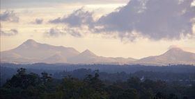
The summit in the Range is Flinders Peak reaching 679 m above sea level. Other mountains include Mount Joyce, Mount Blaine, Mount Goolman, Mount Elliott, Mount Flintoff, Mount Welcome and Ivorys Rock. The range is visible from many locations around the Scenic Rim.
Landforms
The southern-most mountain of the Range is Mount Joyce, which is separated from the Dugandan Range by Teviot Brook.
History
The local Ugarapul people call Flinder's Peak, Booroong'pah or Booroongapah. It is a sacred site because they believe that the powerful spirit, "Yurrangpul", lives there, and guards their traditions and sacred places. His name is similar to the local word for green tree frog: "Yurrang". The green tree frog is the totem of the Ugarapul people. Mount Blaine is known to the Ugarapul people as Ginginbaar, and the Ugarapul meaning for Goolman, used in Mount Goolman, is Axe.
Naming
Teviot Range derived its name after the River Teviot, Roxburghshire, Scotland, on 6 August 1828 by Allan Cunningham (1791–1839) botanist and explorer. The landforms of the Range derived their names as follows:
Water catchment
The Range drains into both the Bremer River Basin (sub-basin of Brisbane River Basin) and via Teviot Brook into the Logan River Basin (sub-basin of Logan-Albert River Basin). Teviot Brook is a major tributary of the Logan River that also supplies water to Wyaralong Dam.
Land ownership and control
The Flinders-Goolman Conservation Estate is a collection of freehold and public land that is either owned or controlled by Ipswich City Council. Additionally, they are not protected areas dedicated under the Nature Conservation Act 1992.
The Flinders Peak Conservation Park is entirely surrounded by (and separate from) the Flinders-Coolman Conservation Estate. The Conservation Park is controlled by the Queensland Department of Environment and Resource Management with the trustee being Ipswich City Council.
The Flinders-Coolman Conservation Estate and the Flinders Peak Conservation Park do not cover the entire lands of the Teviot Range.
Flinders Peak track
Flinders Peak Track, used to access Flinders Peak, was closed to the general public by Ipswich City Council in November 2009 in the interest of public safety. One section of the track was deemed too difficult for the general public to negotiate so Council are endeavouring to re-align it for safer public access. All other tracks within the Estate have remained open. Some social commentators question the reason why the Flinders Peak Track is closed. It has since been reopened, with a slight detour of the area in question.
Boonah to Ipswich Trail
As of December 2010, the Queensland Department of Infrastructure and Planning were consulting stakeholders in regard to developing the Boonah to Ipswich Trail, a 68 kilometre multi-use non-motorised recreation trail, in partnership with five local Councils. The development of the Trail is in accordance with the South East Queensland Regional Trails Strategy (2007). The 19 kilometres located within Ipswich City is planned to wind through the Flinders Goolman Conservation Estate and also will be the northern terminus of the Trail. At the foot of Mount Joyce against Teviot Brook a recreation park is planned to incorporate the Boonah to Ipswich Trail.