
Comarca Oviedo Area 168.9 km² Population 1,807 (2014) | Highest elevation 1,983 m (6,506 ft) Local time Thursday 4:07 AM Province Asturias | |
 | ||
Weather 10°C, Wind SW at 5 km/h, 69% Humidity Points of interest Prehistoric Park Teverga, TeverAstur Senda del Oso, Colegiata de San Pedro de, Cascada Del Xiblu, Villa de SUB | ||
Teverga (Asturian: Teberga) is a municipality in the Autonomous Community of the Principality of Asturias, Spain. It is bordered on the north by Belmonte de Miranda, Grado, Yernes y Tameza, and Proaza; to the south by León province, to the west by Somiedo and to the east by Quirós and Proaza.
Contents
Map of Teverga, Asturias, Spain
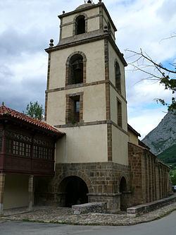
Formerly a mining area, now its economy is based on agriculture and emerging tourism. The tourism is based on the area's beauty and historical interest. The peak Sobia is distinguished by its impressive vertical walls of limestone and its flat top. The collegiate church of San Pedro, in a high medieval style, dates from between 1069 and 1076. One can explore the mountains and the 12-km long Huerta Cave, the Senda del Oso bicycle path, or a museum of prehistory.
In 2013, Teverga was prized with the Exemplary Town of Asturias Award, of the Prince of Asturias Awards. Because of this recognition, Felipe, Prince of Asturias, visited the town in October 2013.