
- elevation 6,027 ft (1,837 m) - average 829 cu ft/s (23 m/s) Discharge 23.47 m³/s Basin area 2,927 km² Mouth Henrys Fork | - elevation 4,829 ft (1,472 m) Length 131 km Basin area 2,927 km² | |
 | ||
- max 1,700,000 cu ft/s (48,139 m/s) | ||
The Teton River is an 81.5-mile-long (131.2 km) tributary of the Henrys Fork of the Snake River in southeastern Idaho in the United States. It drains through the Teton Valley along the west side of the Teton Range along the Idaho-Wyoming border at the eastern end of the Snake River Plain. Its location along the western flank of the Tetons provides the river with more rainfall than many other rivers of the region.
Contents
Map of Teton River, Idaho, USA
CourseEdit
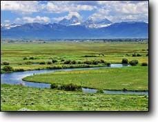
The Teton River is formed near Victor in Teton County, Idaho, near the Wyoming state line, by the convergence of several small creeks that descend from surrounding mountains. Several of these creeks, including Teton Creek and Darby Creek, descend from the western flank of the Tetons. Trail Creek descends from the Caribou-Targhee National Forest in Idaho, meeting the other creeks from the south. The river flows north in a slow meandering course through a broad flat valley called the Teton Basin (formerly known as "Pierre's Hole"), flanked by the Teton Range to the east and the Big Hole Mountains to the west. Much of the river's upper course in the Teton Basin is surrounded by extensive wetlands.
After emerging from the north end of the Teton Basin, the Teton River enters the nearly inaccessible Teton Canyon, approximately 25 miles (40 km) long, along the Teton-Fremont county line. There it is joined by Badger Creek and Bitch Creek from the east, then turns west, and is joined by Canyon Creek from the south. After passing through the failed Teton Dam site, north and east of Newdale, the Teton River bifurcates into two distributaries some four miles downstream, just north of Teton, one called the South Fork Teton River (also called the South Teton River) and the other called North Fork Teton River (also known as the Teton River). The South Teton River travels generally southwest until it joins Henry's Fork west of Rexburg at the southwest end of a large inland delta region on the Henry's Fork, essentially merging with the delta from the east as one of its channels. The Teton River itself (North Fork Teton) continues to travel west, where it joins the Henry's Fork at Warm Slough.
HistoryEdit
At the time of the arrival of the Europeans to the region in the 1820s, the area was inhabited by the Shoshone and various related tribes. The lushness of the Teton Basin provided prime area for the fur trade, attracting many other tribes to region, including the Nez Perce, Flathead and the Gros Ventre. At the time, the basin was part of the disputed Oregon Country. The resulting friction between the trading groups led to recurring skirmishes in the basin. In 1832, a trade rendezvous gone awry resulted in the Battle of Pierre's Hole between the Gros Ventre and a party of American trappers, led by William Sublette and aided by their Nez Perce and Flathead allies. In the brief but bloody battle at least twenty-six Gros Ventres were killed, including women and children, and perhaps a dozen whites and Flatheads. Sublette receives severe injuries and returned east to the United States for medical care.
The most famous modern incident along the river occurred on June 5, 1976 when the earthen Teton Dam in Teton Canyon collapsed, killing 11 people in the valley below. The force of water due to the dam failure destroyed the lower part of the Teton River, washing away riparian zones and reducing the canyon walls. This seriously damaged the stream ecology, and the native cutthroat trout population has been endangered. The force of the water and excessive sediment also damaged stream habitat in the Snake River and some tributaries.