
Length 35 km | Country United States of America | |
 | ||
Counties Massachusetts: Norfolk and Bristol counties.
Rhode Island: Providence County. Main source Savage Pond in Plainville, Massachusetts River mouth Seekonk River in East Providence, Rhode Island River system Narragansett Bay River System Basin size 54 square miles (140 km) Bridges Boston and Providence Railroad Bridge | ||
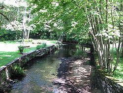
The Ten Mile River is a river within the U.S. states of Massachusetts and Rhode Island. It flows approximately 22 miles (35 km) and drains a watershed of 54 square miles (140 km2).
Contents
- Map of Ten Mile River East Providence RI USA
- CourseEdit
- CrossingsEdit
- TributariesEdit
- Grassroots organizationsEdit
- References
Map of Ten Mile River, East Providence, RI, USA
The North Attleborough National Fish Hatchery is located in its upper reaches, and the river offers stocked trout fishing in the spring.
The Ten Mile River was badly polluted in the mid 1900s but has subsequently been remediated. Although there are still issues with metals and sediments in the water, the river and nearly all its tributaries are now designated as Class B waters (fishable, swimmable).
CourseEdit
The river begins at Savage Pond, near the corner of High and Chestnut Streets, in Plainville, Massachusetts. From there, it flows generally south through North Attleborough, Attleboro and Seekonk before entering Rhode Island and flowing through Pawtucket and East Providence where it flows over the Omega Dam into the Seekonk River.
CrossingsEdit
Below is a list of all crossings over the Ten Mile River. The list starts at the headwaters and goes downstream.
TributariesEdit
In addition to many unnamed tributaries, the following brooks and rivers feed the Ten Mile: