
Primary inflows Area 5.11 km² Outflow location Havel | Surface elevation 29 m Length 5.8 km | |
 | ||
Max. length 5.8 kilometres (3.6 mi) Max. width 1.2 kilometres (0.75 mi) Surface area 5.11 square kilometres (1.97 sq mi) Similar Schwielowsee, Castle Caputh, Einsteinhaus, Sacrow–Paretz Canal, Sacrower See | ||
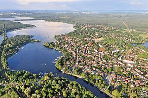
Templiner See is a lake in the state of Brandenburg, Germany. It stretches to the south and west from the centre of the city of Potsdam.
Map of Templiner See, Germany
The lake is some 5.8 kilometres (3.6 mi) long, with a maximum width of 1.2 kilometres (0.75 mi) and a surface area is 5.11 square kilometres (1.97 sq mi). It lies at an elevation of 29.4 metres (96 ft) above sea level, and has a maximum depth of 6 metres (20 ft).
The navigable River Havel flows through the lake, entering it at its northern end adjacent to central Potsdam, and leaving it at its southern end via a short channel to the Schwielowsee between Caputh and Geltow. The lake is crossed by two cable ferries, the Kiewitt Ferry towards its northern end, and the Caputh Ferry at its southern exit. Navigation is administered as part of the Untere Havel–Wasserstraße.
At the northern end of the lake, the peninsula of Hermannswerder protrudes into the lake. At about its midpoint, the lake is crossed by the Berlin outer ring railway, using an embankment and bridge. This was built in the 1950s, to bypass West Berlin during the division of Germany.