
Type Geological formation Thickness 30 m Underlies Redwall Limestone | Primary dolomite Overlies Muav Limestone | |
 | ||
Other sandstone, mudstone, and limestone Region Northern Arizona (Grand Canyon), central Arizona
& (southern) Nevada Country United States of America Named for Temple Butte, Coconino County, Arizona. | ||
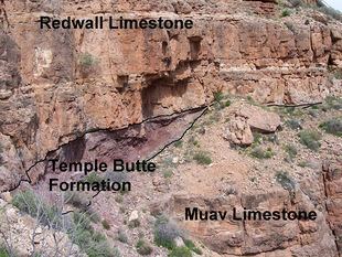
The Devonian Temple Butte Limestone outcrops through most of the Grand Canyon, Arizona, USA; it also occurs in southeast Nevada. Within the eastern Grand Canyon, it consists of thin, discontinuous lenses, and relatively inconspicuous lenses that fill paleovalleys cut into the underlying Muav Limestone. Within these paleovalleys, it at most, is only about 100 feet (30 m) thick at its maximum. Within the central and western Grand Canyon, the exposures are continuous. However, they tend to merge with cliffs of the much thicker and overlying Redwall Limestone.
Contents
Within the western and central parts of the Grand Canyon, the Temple Butte Limestone consists of a westward thickening layer of interbedded dolomite, sandy dolomite, sandstone, mudstone, and limestone that vary in color from purple, reddish-purple, dark gray, to light-gray. Within the eastern part of the Grand Canyon, the Temple Butte Limestone fills shallow paleovalleys, which are eroded into the underlying Tonto Group. The Temple Butte strata filling these paleovalleys consist of interbedded mudstone, sandstone, dolomite, and conglomerate – that vary in color from purple, reddish-purple, to light gray. Typically, the paleovalley-fill consists of a distinct pale, reddish purple dolomite or sandy dolomite. These paleovalleys range in depth from as much as 100 feet (30 m), to as shallow as 40 feet (12 m).
The upper and lower contacts of the Temple Butte Limestone are major unconformities. Within the Grand Canyon region, its base is a major unconformity within the Paleozoic rock record. The time represented by this unconfomity spans about 100 million years, including part of Late Cambrian, all of Ordovician and Silurian, and most of Early and Middle Devonian time. The upper contact is a disconformity that typically consists of nearly horizontal surfaces with little or no relief and overlain locally by a basal conglomerate within the overlying Redwall Limestone.
Within the area of Frenchman Mountain, Clark County, Nevada, over 2,000 feet (610 m) of limestone and dolomite occupy the interval between the Muav and Redwall limestones, where in the Grand Canyon there exists less than 100 feet (30 m) of Temple Butte limestone. These limestone and dolomite beds represent sediments that accumulated during the period of time represented by the two disconformities that from the upper and lower contacts of the Temple Butte Limestone in the Grand Canyon.
Geologic sequence
Sequence of Lower to Middle Paleozoic Strata:
(Late Cabrian, all of Ordovician & Silurian, and Early & Middle Devonian)